Today I road up Mount Diablo, to the ranger station junction, for the first time in 2-3 years and only the second time ever. The first and last time I did this ride it was just too much for me, and I kinda figured that I would never want to do it again. But I've been doing a lot more climbing this season, so I thought I should give it another try and see if it was as bad as I remembered.
Mount Diablo is one of the three major peaks in the bay area (along with Mt Tamalpais in marin and Mt Hamilton in the south bay) and a favorite ride for lots of cyclists. There are two approaches to the ranger station, Northgate and Southgate. From the junction of that two roads, at 2200 feet, it's another 4.5 miles to the summit, which is about 3800 feet. Both times I've done this ride I've followed the Yellowjackets routesheet, which leads you up the more gently graded Southgate to the junction and then down Northgate.
Anyway, from the base of Southgate to the junction is a steady 6 mile climb. The average grade on this road is apparently 4.5%, but there are sections in the first 2 miles that are steeper. To my surprise I really didn't find the ride that difficult this time around. In fact I actually enjoyed it quite a bit, so I guess that means that I've become much better at climbing over the past couple of years. Whee! It took me pretty much exactly 1 hour to reach the junction, which isn't gonna break any records but it's pretty good for me. Next time I'll either try to improve on that time or try for the summit.
Oh, and a shoutout to the guy who helped me with my flat tire at the entrance to Southgate. I went to fix my flat and realized that the guy at the shop who installed my new cassette put my quick release on so tightly that I couldn't open it. Jerk. So thanks to the guy to stopped to helped me open it and then proceeded to fix my flat for me.
Total miles: 34
Total time in the saddle: 3 hours
Elevation gain: 2300 feet
Sunday, September 23, 2007
Saturday, September 22, 2007
Calistoga Loop (52 miles)
On Thursday I left work early and drove up to Calistoga for a couple of days to relax and rejuvenate. Naturally I took along one of the bikes for a little jaunt on Friday. I ended up taking the Terry touring bike, since I figured I might be stopping at a winery along the way and would then need the use of the panniers to carry back purchases. While in Calistoga I stayed at the Indian Springs Resort, my favorite place in Calistoga. They have a huge (like Olympic size) mineral pool fed from their own geyser right next to the pool. I love it.
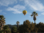 Oh, and then on Friday morning when I woke up and popped my head outside, this beautiful hot-air balloon was passing right over the resort. Ah, wine country...
The ride, called the "Reverse Calistoga" loop, is from the Oakland Yellowjackets routesheet library. My total mileage was 6-7 miles higher since my starting point was in downtown Calistoga. The route is pretty straightforward: you follow Silverado Trail a couple of miles, then turn east for a bit of a climb up Deer Park/Howell Mountain road, then take Ink Grade to Chiles Pope Valley to Lake Hennessey. Then it's back up Silverado Trail. There was a steady climb up Deer Park/Howell Mountain, but it wasn't too bad, topping out at around 1800 feet before I turned onto Ink Grade. Ink Grade is a well-known climb in the north bay (it's featured in most of the centuries in the napa area) so I was expecting some pretty harsh climbing at this point. But it turns out that this route approached Ink Grade from the other end so all I had to do was descend. Maybe that's why they call this route the "reverse" Calistoga. Whatever. I was quite happy to be plunging down this grade rather than slogging up it.
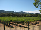 The rest of the ride was really nice. The route takes you through vineyards and farmland, by the incredibly dry Lake Hennessey, and through two villages, Angwin and Pope Valley. Not many services to be had in this back country, so I was glad to have my panniers with plenty of food and water.
Animules: 2 foxes (I think), several deer, many lazy cows
Total Miles: 52
Elevation Gain: 3900 ft
Route map (bikely.com): Calistoga Loop
Wine Notes
As long as I'm up in wine country, it seems stupid to not do a little bit of winetasting, right? So on Friday, right after finishing up the ride, I headed over to Vincent Arroyo. I've been meaning to visit this place for quite some time. It's off the beaten path a bit, but I had heard that they had very good wines and that they sell out of their small production early in the season. Turns out that you're supposed to have an appointment for tasting, but Dave, my host, graciously signed me up for an impromptu appointment. I thought I was pretty special to receive this treatment until I saw them do the same for other walk-ins. Apparently they aren't zoned for a public tasting room, but they are happy to accommodate a small number of walk-ins.
Vincent Arroyo produces only about 8000 cases a year, and most of that is sold on pre-order before it's even bottled. I bought a bottle of their 2006 Chardonnay, which is lightly oaky with a bit of citrus, and a 2005 Petite Syrah, their signature wine. I also tried the 2005 Melange reserve (a gamay blend) and the 2005 Entrada, a blend of old vine Syrah, Petite Syrah, and Cabernet. It was a very elegant wine with a smooth finish, but at $65 a bottle, a little more than I wanted to pay.
On Saturday, on my way back to town, I stopped in at Heitz Cellars, just outside of St Helena on highway 29. Heitz is known for their Cabernet Sauvignons, particularly the Oakville "Martha's Vineyard" label. After trying their 2005 Chardonnay and a Verdot, I tasted the 2002 "Trailside Vineyard" Cab, then the 1998 Bella Oaks Cab. I actually preferred the latter because it had a lovely smooth finish, but that's probably due in part to the fact that it was 1998, right? Next I sampled three ports-- the Ink Grade port, the "vintage" Ink Grade port, and the Grignolino ruby port, that has an interesting citrus aroma that I don't think I've run across in ports. After all this, the host poured me a bit of their signature Martha's Vineyard cab, but my palette was pretty overloaded at that point. I'm sure it was delicious though. So, I ended up buying two bottles of the Chardonnay, one bottle of the Verdot, and one bottle of each of the ports. Yeehah!
Oh, and then on Friday morning when I woke up and popped my head outside, this beautiful hot-air balloon was passing right over the resort. Ah, wine country...The ride, called the "Reverse Calistoga" loop, is from the Oakland Yellowjackets routesheet library. My total mileage was 6-7 miles higher since my starting point was in downtown Calistoga. The route is pretty straightforward: you follow Silverado Trail a couple of miles, then turn east for a bit of a climb up Deer Park/Howell Mountain road, then take Ink Grade to Chiles Pope Valley to Lake Hennessey. Then it's back up Silverado Trail. There was a steady climb up Deer Park/Howell Mountain, but it wasn't too bad, topping out at around 1800 feet before I turned onto Ink Grade. Ink Grade is a well-known climb in the north bay (it's featured in most of the centuries in the napa area) so I was expecting some pretty harsh climbing at this point. But it turns out that this route approached Ink Grade from the other end so all I had to do was descend. Maybe that's why they call this route the "reverse" Calistoga. Whatever. I was quite happy to be plunging down this grade rather than slogging up it.
The rest of the ride was really nice. The route takes you through vineyards and farmland, by the incredibly dry Lake Hennessey, and through two villages, Angwin and Pope Valley. Not many services to be had in this back country, so I was glad to have my panniers with plenty of food and water.Animules: 2 foxes (I think), several deer, many lazy cows
Total Miles: 52
Elevation Gain: 3900 ft
Route map (bikely.com): Calistoga Loop
Wine Notes
As long as I'm up in wine country, it seems stupid to not do a little bit of winetasting, right? So on Friday, right after finishing up the ride, I headed over to Vincent Arroyo. I've been meaning to visit this place for quite some time. It's off the beaten path a bit, but I had heard that they had very good wines and that they sell out of their small production early in the season. Turns out that you're supposed to have an appointment for tasting, but Dave, my host, graciously signed me up for an impromptu appointment. I thought I was pretty special to receive this treatment until I saw them do the same for other walk-ins. Apparently they aren't zoned for a public tasting room, but they are happy to accommodate a small number of walk-ins.
Vincent Arroyo produces only about 8000 cases a year, and most of that is sold on pre-order before it's even bottled. I bought a bottle of their 2006 Chardonnay, which is lightly oaky with a bit of citrus, and a 2005 Petite Syrah, their signature wine. I also tried the 2005 Melange reserve (a gamay blend) and the 2005 Entrada, a blend of old vine Syrah, Petite Syrah, and Cabernet. It was a very elegant wine with a smooth finish, but at $65 a bottle, a little more than I wanted to pay.
On Saturday, on my way back to town, I stopped in at Heitz Cellars, just outside of St Helena on highway 29. Heitz is known for their Cabernet Sauvignons, particularly the Oakville "Martha's Vineyard" label. After trying their 2005 Chardonnay and a Verdot, I tasted the 2002 "Trailside Vineyard" Cab, then the 1998 Bella Oaks Cab. I actually preferred the latter because it had a lovely smooth finish, but that's probably due in part to the fact that it was 1998, right? Next I sampled three ports-- the Ink Grade port, the "vintage" Ink Grade port, and the Grignolino ruby port, that has an interesting citrus aroma that I don't think I've run across in ports. After all this, the host poured me a bit of their signature Martha's Vineyard cab, but my palette was pretty overloaded at that point. I'm sure it was delicious though. So, I ended up buying two bottles of the Chardonnay, one bottle of the Verdot, and one bottle of each of the ports. Yeehah!
Sunday, September 16, 2007
Orinda-Palomares
Today I did the Orinda-Palomares ride again, for the first time since early June. This is one of my favorite rides in the east bay, but it's really a spring or fall ride (it's a bit too warm in the summer for it). I got a chance to try out my new cassette on the climb up Palomares Road, and I was pleased that the additional granny gear on the new cassette really made a difference on the steep sections. I used to wish I had just one lower gear on some of these climbs, and now I do! Whee!
Animules: lots of deer on Palomares Road
Distance: 58 miles
Elevation gain: 2300 feet
Time in the Saddle: 4.5 hours
Route: Orinda-Palomares (bikely.com)
Animules: lots of deer on Palomares Road
Distance: 58 miles
Elevation gain: 2300 feet
Time in the Saddle: 4.5 hours
Route: Orinda-Palomares (bikely.com)
Sunday, September 9, 2007
new cassette and then some
I mentioned a couple of weeks ago that I had ordered a new 28-11 8-speed cassette for the Dolce. It finally came in this week, but after the shop installed it, the mechanic noticed that the pulley of the rear derailleur was rubbing against the lowest gear. Turns out that rear derailleurs are designed for a maximum size rear sprocket, and if you exceed this max size by too much, the jockey pulley rubs against the low gear sprocket. Who knew?
My options were: put the old 25-12 cassette back on or keep the new cassette and buy a new, better derailleur. So now I have a new cassette and a new Ultegra GS rear derailleur. Woohoo!
My options were: put the old 25-12 cassette back on or keep the new cassette and buy a new, better derailleur. So now I have a new cassette and a new Ultegra GS rear derailleur. Woohoo!
Dumbarton-Palo Alto ride
Last weekend on my Half Bay in a Day route, I rode over two of the three major bay area bridges that are open to cyclists ( the Golden Gate and the new Carquinez). So today I decided to traverse the third, the Dumbarton bridge, which is the southern-most bridge that crosses the bay, linking Fremont on the east bay with Palo Alto on the peninsula. I followed the Oakland Yellowjackets' routesheet (pdf), but I started at a different BART station to tack on a few extra miles.
Overall, this is a relatively uninspiring ride. It takes you through some nice parts of Palo Alto, Portola, and Woodside on the peninsula (ground I've covered on several other peninsula rides), but the bridge itself isn't all that interesting, and frankly, the areas surrounding the bridge smell really bad. The one area that was a bit interesting was the marshlands on the Fremont side of the bridge. This is the second weekend in a row that I've stumbled upon some interesting bay area marshlands that I had no idea even existed. I probably don't associate the bay area with wetlands because San Francisco and the east bay shoreline have filled them all in. Anything that was swamp back in the 19th century is now land-fill, of course. I've been reading on the internets that 85% of the bay area's original marshes and shorelines have been altered in the last 150 years. But it seems that there are these pockets around the bay-- in Marin, in the north San Pablo bay area, and in this area of Fremont-- where agencies have attempted to preserve and restore the natural shoreline habitats.
This one is called the Don Edwards San Francisco Bay WIldlife Refuge. This was the first urban National Wildlife refuge in the U.S., and it covers 30,000 acres of bay, salt ponds, marsh, etc. They have a beautiful visitors center and several nature hike trails, so I definitely plan on returning there when I have a bit more time to explore.
But enough of the positive, let's talk about the negative! Maybe it's my long biking season wearing me down, and/or the 3200 miles I've puts on the bikes since January, but I've developed some pet peeves that really prevent me from fully enjoying a ride. All three were present on the Dumbarton ride:
1. Poor road quality. I swear there are maybe 5 roads in the entire bay area that are not collections of poorly patched potholes, tree root cracks, earthquake fissures, and small boulders. Is this a conspiracy to make us all buy expensive carbon frame bikes? I actually have things fall off of my bikes because of the poor quality of the roads. Oh well, I guess I didn't need that rear reflector anyhow.
2. Headwinds. Seriously, it is possible to have headwinds in every direction during a single ride? Wtf?
3. Shards of glass in the bike lane, covering the entire width of the bike lane, just for good measure. I know we all love the smashy-smashy, but can we be a little less ghetto in the ghetto?
Speaking of ghetto, I parked my car at the Fruitvale BART station and when I got back in the afternoon I noticed that the lock on my driver's side door was a bit wonky, and there were papers and junk strewn about the passenger seat. So, somebody broke into my car (by opening my incredibly secure door lock), went rummaging through my glove box, map slots, ash tray (?), but didn't take anything. I don't keep anything of real value in the car because people keep fucking breaking into it, but I did have my stereo face and several CDs in one of the compartments and they were left untouched. Either they didn't look in there or they don't like my taste in music. But who doesn't love Lynyrd Skynyrd?!
Apparently my model of Toyota has the world's easiest locks to pop open. I wouldn't really mind them taking a peek inside, but their handiwork is really screwing up the lock mechanisms on the doors. At this point the passenger side door lock is completely busted, and now the driver's side is getting pretty bad. Thanks a lot hoodlums.
Total Miles: 60
Time in the saddle: 5 hours
Elevation gain: 1100 feet
Sunday, September 2, 2007
Half Bay in a Day
Last week I had a brilliant idea: to circumnavigate the San Francisco bay over the course of 2 days. I would start in San Francisco and travel clockwise, passing through Marin and the North Bay on the first day, then begin day two in Oakland and travel through the east bay, across the Dumbarton bridge, and up the peninsula to finish in SF. That was the plan. I ended up completing the first leg, from SF to Oakland, but then lost my motivation for the second day. Which is why this entry is called "Half Bay in a Day" rather than "Bay in 2 Days".
I've mentioned elsewhere that there's a plan to eventually encircle the bay with a multi-use path called the Bay Trail. Right now there are huge gaps in the trail and some sections are unpaved, so until it's completed, you have to piece together a route around the bay based on the existing network of paths, bike lanes, designated bike routes, highways, etc. While there were some interesting sections of the ride, like the north bay marshlands and traveling over the new span of the Carquinez bridge, overall it wasn't that pleasurable. I think I'll wait until the Bay Trail is complete before trying it again.
The route begins at the Ferry Building in San Francisco, and follows the well-traveled route along the waterfront, over the Golden Gate bridge, through Sausalito, Corte Madera, San Rafael, and Novato. This stretch of the route through Marin (about the first 35 miles or so) was very pleasant, although once you get through Sausalito, the bay is out of sight for quite a while. I could have followed a different route closer to the water, one that goes by San Quentin, but that's not all that pleasant. Side note: isn't it strange how, in the bay area, the maximum security prisons occupy great waterfront property? They could move San Quentin to Bakersfield and convert that land to expensive condos in a flash.
At around mile 40 the route joins Highway 37, which is the only way to get from Novato to Vallejo and is, I believe, technically a "freeway" in certain spots. I really don't enjoy riding on the shoulder of freeways for 15 miles, with cars and tanker trucks zipping by at 65+. However, this highway does have a nice generous shoulder the entire stretch, with those safety bumps providing an extra buffer between you and the cars. It wasn't an ideal cycling road, but it's kind of the only option if you want to get from point A to point B in this part of the bay. So I just plugged in the iPod, put my head down, and tried to blast through this stretch as quickly as possible.
The terrain right along the water in the north bay is unspectacular, but vaguely interesting: it's all salt water marsh where the Petaluma River, Tolay Creek, and Sonoma Creek all enter the bay. Apparently this is area is called the Napa-Sonoma Marsh, and represents a prime example of tidal wetlands. There are several spots along the highway where you can pull off and find trailheads and wildlife viewing spots. So that was kind of interesting. Also, everytime I'm around marshes I think of that X-Files episode with Luke Wilson, where Mulder asks if there are any swamps in the area, and the Sheriff says "We used to have swamps, only the EPA made us take to calling 'em wetlands." Heh.
Past the wetlands, the route takes you through a ghetto-y part of Vallejo to the new Carquinez bridge span, the Alfred Zampa Memorial Span. Go Afred, you got your own bridge! The new span has a lovely bike-pedestrian lane along the western side of the bridge, joining the Golden Gate and the Dumbarton as the select bridges in the bay area with bicycle access. I'm looking at you, Bay Bridge...
The Carquinez bridge dumps you into Crockett, from where you take a lovely little tour past the ConocoPhillips oil refinery. Nasty! After that, the last 10 miles wind through east bay suburbs (Rodeo, Hercules, El Sobrante, etc.) back to sweet, sweet home Oaktown.
Total Miles: 80
Time in the saddle: 7.3 hours
Elevation gain: 3400 feet
route: SF-Oakland via north bay
Subscribe to:
Posts (Atom)
