This was to be my weekend of riding up Diablo three times, but the air quality has been so crappy (due to all the forest fires), that I had to scrap that idea and head to the coast. The air on the coast wasn’t perfect, but it had the best particle reading in the bay area. And it was probably still better than your average day in southern California.
On my recent rides up Tam, I’ve been taking the northern approach via Fairfax. It’s longer and a bit more challenging, but it doesn’t have the traffic of Panoramic Highway. However for this ride, I was looking for efficiency, so I ended up taking the route through Mill Valley and Panoramic that I had followed on my first ride up to the ranger’s station last year. Actually that was almost a year ago to the day.. how fitting! Anyway, the ride up to Pan Toll station wasn’t nearly as bad as I remembered it. In fact there was a nice flat stretch in the middle where I was able to accelerate quite a bit. It probably helped that it was overcast and chilly, so no chance of overheating or dehydrating. From the station I headed up to the summit (west peak on this first pass) and then turned around to descend down to Stinson Beach.
From Stinson, it’s a much shorter approach to get to the summit: 3.7 miles to the station, 1.5 to the junction with the ridge, and then 3 miles to the visitors center on the east peak. A construction crew was up there working on some expansion to the center, and the snack bar was closed (!) but there were hordes of cyclists up there. Looked like it might have been a couple of club rides.
For the third and final pass, I again descended down to Stinson and then climbed back to the ranger station. I really started feeling fatigued on this final climb and it took all my energy to get through it. For the first time in a long time, I was actually sore after this ride. Somehow I managed to work my inner thigh muscles to the point that they were stiff and sore after the drive home. I suspect that on that final climb, I wasn’t keeping my knees lined up correctly and was probably swinging my legs out a bit to find some extra power.
For those of you keeping score at home, the three climbs today measured:
12.5 miles, 2500 feet (west peak)
8.3 miles, 2540 feet (east peak)
3.7 miles, 1400 feet (to Pan Toll ranger’s station)
The three passes I want to complete for the Death Ride are:
Front side of Monitor: 13.3 miles, 2700 feet
Front side of Ebbetts: 10.4 miles, 2700 feet
Back side of Ebbetts: 4.8 miles, 1500 feet
So I came very close today to the real elevation gain I’ll be seeing in 2 weeks. It was a perfect training ride, and I’m as ready as I’ll ever be for the real thing.
Animules: One deer crossing Panoramic Highway
Total Distance: 50 miles
Elevation gain: about 7000 feet
Time in the Saddle: 5 hours 45 minutes
Sunday, June 29, 2008
Tuesday, June 24, 2008
Upcoming Tour in the Adirondacks – routes
Have I mentioned that I’m going to the Adirondacks the first week of July for some cycling? I may not have, since R did pretty much all the planning for the trip (thanks R!). Even though all I really have to do is show up, I feel compelled to do some amount of analysis of the routes. Some people like to be surprised, they enjoy spontaneity and the unknown. Not me; I like to know what I’m getting myself into. So, I ended up plotting a few of the possible routes using Bikely.com. All these routes are based on the book 25 Bicycle Tours in the Adirondacks.
North Creek vicinity (our base camp, or base B&B rather):
The Lakes of Chester
About 38 miles and 2600 feet of climbing.
Teddy’s Trail
One of the two longer routes at about 80 miles and about 5000 ft (?) of climbing. Bikely.com is crapping out on the elevation profile at the moment for this one.
Reverse Speculator
This route was already plotted on bikely. It’s the same as the “Speculator” route from the book, but in the reverse direction. 75 miles and 4100 feet of climbing (seems like hardly any elevation gain at all for that long of a ride).
Minerva-Olmstedville
Only 17 miles and about 1500 feet, but looks like lots of rollers from the elevation profile.
Lake George vicinity
Bolton Landing
30 miles, 2400 feet of climbing. Seems like a nice relatively relaxing tour.
Lake Luzerne
38 miles, 2750 feet of climbing.
Sunday, June 22, 2008
Mt Tam-Stinson Ride (49 miles)
Today’s ride combined the route for the Mt Tam loop with a little extra descent to, and climb back up from, Stinson Beach. Our little heat wave finally broke today, so the weather was perfect: sunny and warm but comfortable. Even so, remembering my water woes last time, I brought my camelback and two water bottles. I wasn’t taking any chances; and in fact I felt like I did a much better job hydrating this time around.
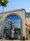 On this pass through Fairfax, I skipped the weird coffee shop with the bad live music, although as I was cruising by, I caught this guy working on a mural on the side of the building. He was making quick work of it too, with Pink Floyd or something similar blaring from his stereo.
The approach past Alpine Lake Dam and on up to Ridgecrest Road felt a little easier this time, but I still struggled mightily on Ridgecrest. This stretch is only about 4 miles and only gains about 600 feet, but it’s all steep rollers, which are my least favorite type of hill. I was huffing and puffing along when a couple of guys passed me, one saying to me, “Do your friends know you’re out here climbing mountains? They must think you’re crazy!”. Heh. Yeah, kinda. I told them I was training for the Death Ride, and it turns out he’s done it like 5 years in a row. He said one year he even did the ride with his wife on a tandem. Took them all day. You know, I have a certain mental image of the kind of ride where a tandem would be fun, and the Death Ride ain’t it. At any rate, I ran my 3 pass plan by him (Monitor, 2 Ebbetts) and he said it was a good plan. He also said the front side of Ebbetts will be the most challenging for me.
From Ridgecrest, the climb up to the summit wasn’t bad at all. I love that they have a snack bar up at the visitors’ center. Nothing like a cold root beer after climbing a mountain.
From the summit, I descended to the ranger station, and then faced a choice: turn left and have quick descent back to Sausalito, or turn right, descend to Stinson Beach and then climb back up. I really needed to get a bit more climbing in, so I chose the Stinson option. This route to Stinson via Panoramic Highway is really lovely, continuing through the woods and then thrusting you out onto the ridge overlooking the Pacific. It would be an awesome descent if it weren’t for the horrid state of the road and the car traffic. I was a little worried about the traffic climbing back up from Stinson, because there’s really no shoulder on this road. There were a few cars, but I guess it was early enough that people were still enjoying the beach. The climb ended up being pretty enjoyable, at about 4 miles and 1500 feet. The cool sea breeze on the ocean side was particularly refreshing. And with that extra climb in, I was able to cruise back to Sausalito feeling like I had put in a good day’s work.
Next weekend will be the final official training ride before the Adirondacks trip and the Death Ride following that. So on Saturday, my goal is to do at least 50 miles and 6500 feet of climbing.
Total Distance: 49 miles
Animules: several deer in Mill Valley
Elevation gain: about 5500 feet
Time in the Saddle: 5 hours 17 minutes
Elevation profile (from Klimb software):

On this pass through Fairfax, I skipped the weird coffee shop with the bad live music, although as I was cruising by, I caught this guy working on a mural on the side of the building. He was making quick work of it too, with Pink Floyd or something similar blaring from his stereo.The approach past Alpine Lake Dam and on up to Ridgecrest Road felt a little easier this time, but I still struggled mightily on Ridgecrest. This stretch is only about 4 miles and only gains about 600 feet, but it’s all steep rollers, which are my least favorite type of hill. I was huffing and puffing along when a couple of guys passed me, one saying to me, “Do your friends know you’re out here climbing mountains? They must think you’re crazy!”. Heh. Yeah, kinda. I told them I was training for the Death Ride, and it turns out he’s done it like 5 years in a row. He said one year he even did the ride with his wife on a tandem. Took them all day. You know, I have a certain mental image of the kind of ride where a tandem would be fun, and the Death Ride ain’t it. At any rate, I ran my 3 pass plan by him (Monitor, 2 Ebbetts) and he said it was a good plan. He also said the front side of Ebbetts will be the most challenging for me.
From Ridgecrest, the climb up to the summit wasn’t bad at all. I love that they have a snack bar up at the visitors’ center. Nothing like a cold root beer after climbing a mountain.
From the summit, I descended to the ranger station, and then faced a choice: turn left and have quick descent back to Sausalito, or turn right, descend to Stinson Beach and then climb back up. I really needed to get a bit more climbing in, so I chose the Stinson option. This route to Stinson via Panoramic Highway is really lovely, continuing through the woods and then thrusting you out onto the ridge overlooking the Pacific. It would be an awesome descent if it weren’t for the horrid state of the road and the car traffic. I was a little worried about the traffic climbing back up from Stinson, because there’s really no shoulder on this road. There were a few cars, but I guess it was early enough that people were still enjoying the beach. The climb ended up being pretty enjoyable, at about 4 miles and 1500 feet. The cool sea breeze on the ocean side was particularly refreshing. And with that extra climb in, I was able to cruise back to Sausalito feeling like I had put in a good day’s work.
Next weekend will be the final official training ride before the Adirondacks trip and the Death Ride following that. So on Saturday, my goal is to do at least 50 miles and 6500 feet of climbing.
Total Distance: 49 miles
Animules: several deer in Mill Valley
Elevation gain: about 5500 feet
Time in the Saddle: 5 hours 17 minutes
Elevation profile (from Klimb software):

Sunday, June 15, 2008
Diablo junction x3 – almost (40 miles)
And so we continue the journey toward becoming one of those weirdos who talks not about riding up Diablo but rather about how many times they rode up Diablo. Today, for me, the answer was 2 and two-thirds.
I had set my alarm for 6am this morning, but ended up turning it off and going back to sleep for another hour. I think I fell a bit behind on my R&R, due mostly to stress at work, so I probably really needed that extra hour. However the result was that I didn’t get out to Walnut Creek until about 9am. A bit of a late start.
The first climb was up the north side to the junction. I was feeling a bit sluggish on this first climb, and was disappointed that I wasn’t able to best my last time of 63 minutes. I logged 64.5 minutes which isn’t bad, but I really want to crack an hour before the end of the month.
From the junction I cruised down the south side to the gate, turned around, and then headed back up. Then from the junction, I descended the north side, turned around, and began climbing again, with the goal of reaching the junction for the third time but knowing that it might not happen. I didn’t feel too fatigued, but by this point it was 12:30 and the air temperature was hovering above 80 degrees… and it felt really hot. The north approach has some brief patches of shade, but it’s pretty exposed. I got about two-thirds of the way up, just before the switchbacks begin, and decided to call it a day. I could have gritted my teeth and made it up to the junction (about another 2 miles) but didn’t feel like killing myself for it. I’ve still got a month left before the Death Ride, and I’m on track as far as my training is concerned. Next weekend I’ll start earlier, do the junction 3 times, and maybe throw in a jaunt up to the summit. Who knows?
For those of you keeping score at home, the three climbs today measured:
7.8 miles, 2000 feet (North Gate)
5.6 miles, 1500 feet (South Gate)
5 miles, 1400 feet (North Gate to the switchbacks)
The three passes I want to complete for the Death Ride are:
Front side of Monitor: 13.3 miles, 2700 feet
Front side of Ebbetts: 10.4 miles, 2700 feet
Back side of Ebbetts: 4.8 miles, 1500 feet
Speaking of the Death Ride, I got my jersey and socks in the mail this week, so I wore them on today’s training ride. I don’t know if that goes against jersey etiquette (sporting the apparel before the event) but it was a good motivator. I had an obligation to live up to the skeleton logo on my back. I got several comments from passing cyclists, and one thumbs up from a motorist. Heh.
Animules: Along the side of the road on North Gate I saw the same young coyote. Coulda been his twin brother.
Total Distance: 40 miles
Elevation gain: 5200 feet
Time in the Saddle: 4 hours 15 minutes
Sunday, June 8, 2008
Diablo ranger station x2 (38 miles)
I headed out to Walnut Creek early Saturday morning to climb up the north side of Diablo and try to intersect with Cycling Boss and his crew. They had gotten an extra early start that morning, with the plan of going up North Gate then down South Gate, then back up to the junction. By the time I got up to the junction around 9:30, they were ready to descend back down the north side, turn around, and then come back up to the junction. So my timing was perfect for a second climb.
Incidentally, on this ride up to the junction I logged my best time yet, managing to shave 3 minutes off my previous best time of 66 minutes from the gate to the junction.
My second climb up was a much slower affair, and I really felt it on the steep sections. I certainly didn't set any records the second time up, but I was only 4 minutes slower.. not too bad all things considered. The next step will be to integrate a climb up South Gate into this route. That will get me pretty close to total elevation for my 3-pass Death Ride.
Miles: 38
Total elevation gain: about 4000 feet
Time in the saddle: 3 hours 40 minutes
Subscribe to:
Posts (Atom)
