For my Sunday ride I decided to finally try for the summit of Mt Tamalpais. My four readers will recall that there are three main peaks in the bay area: Mt Diablo in the east bay, Mt Hamilton in the south bay, and Mt Tam in Marin. One of my cycling goals this year was to get to the summit of all three. I did Hamilton in the fall, and have made it up Diablo several times this winter and spring. Last summer, I inadvertently rode up to the ranger’s station of Tam while doing the Stinson Beach-Muir Woods loop, but that was my last attempt.
Of the three peaks, Mt Hamilton is the highest, at about 4200 feet, but arguably the easiest because it’s a very long, gentle grade for almost the entire climb. Diablo’s summit is at about 3800 feet, and I think conventional wisdom is that it’s the tougher climb compared to Mt Tam, with its highest points at about 2600 feet. However, I personally think Mt Tam is a bit more challenging because there are more steep sections of climbing, and both north and south approaches to the summit road are unevenly graded, so it’s hard for me to find a good climbing rhythm. So from a pure climbing perspective, I still prefer my own mountain here in the east bay, but Tam and the surrounding alpine woods win out in the scenery category.
For this ride I followed the Velogirls routesheet, but instead of riding across the Golden Gate bridge I started in Sausalito to make this a 40+ mile loop rather than a 60+ mile loop. From Sausalito, the route follows the Nicasio route for the first ten miles, up the hill to Corte Madera, then through some really charming towns in Marin (downtown Larkspur, Ross, San Anselmo, and Fairfax). In Fairfax, all the cyclists stop at a local coffee shop called the Fairfax Coffee Roastery. I had a good espresso, but they had some random live music (at 9:30 am??) and the guy kept messing up the lyrics to all the songs. And they weren’t new songs, they were all Elton John and James Taylor songs. Everybody knows the lyrics to those old songs, except this guy playing guitar at the Fairfax Coffee Roastery. Go figure.
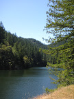 From Fairfax, instead of heading up Sir Francis Drake towards Nicasio, you head south on Bolinas, basically approaching Mt Tam from the north side. I did prefer this approach to the southern route (Panoramic Highway) because there was very little car traffic. In fact, for most of this stretch I heard nothing but birds and crickets in the forest. I think most of the people heading up to the Mt Tam trails or over to the coast take Panoramic Highway rather than the longer, meandering Fairfax-Bolinas route, so you can feel like you’re miles away from civilization on this road. The other nice thing about the road is that it passes by Alpine Lake and the Alpine Dam Bridge, so the scenery is very nice… lots of pine trees surrounding the lake. It’s reminiscent of some of the smaller alpine lakes in the Sierras, near Lake Tahoe, just without the nice clear water. Still, very pretty.
From the Alpine Lake dam up to the ridge at (aptly named) Ridgecrest Road is a gain of about 900 feet in about 2.5 miles, with some pretty steep sections and many switchbacks. I found this part of the ride pretty challenging, but at least it was almost entirely shaded by the surrounding forest. It would be a killer climb if totally exposed.
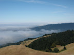
Once I got up to Ridgecrest, I started hitting lots of trailhead parking lots but absolutely no water fountains. I remembered that I experienced this on my Muir Woods ride too; with all the hiking trails in the Mt Tam area (in the Mt Tam watershed no less!), you’d think they’d have more drinking fountains, but you’d be wrong. As a result, by the time I got to the turnoff to start ascending the summit, I had drained my two water bottles and had no fluids left. One guy helpfully suggested that there were drinking fountains at the visitor center up at the summit (great!) but another cyclist came to my rescue and gave me some of his water. My savior! He noted that it had some sports mix in it, so I would feel like “Lance Armstrong” going up the hill.
 So, up I went. According to this new mapping shareware I downloaded, the first section of the summit climb covers 519 feet in 1.4 miles, for a 7% grade. I didn’t find this section that difficult at all (must have been the “sports mix”!). What’s interesting about Mt Tam is that it really has a couple of peaks: the west peak and the east peak. They’re both about 2600 feet, but there’s a dip in between them, so it’s like a false summit with a kick. But I finally did make it to the east peak, where I drank about 40 oz of water and a root beer. That tasted mighty good. They have a nice little visitor center with picnic tables, snack bar, trails, and various lookout points.
 The worst thing about the multiple peak situation is that you have to climb back up on your descent from the summit. It’s cruel and painful, with one section of 6.3% grade and another at 7.8%. But after that, it was literally all downhill to Sausalito.
Total Distance: 42 miles
Animules: a jack rabbit up near the summit
Elevation gain: 4000 feet
Time in the Saddle: 4 hours 23 minutes (wow, that’s pretty slow)

No comments:
Post a Comment