Altnerate title: Yes, you are riding halfway up Mount Tam, stupid.
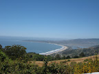
I started at the Ferry building in San Francisco and rode the standard route over the Golden Gate bridge and into Sausalito. In Mill Valley, the route takes you up through some really beautiful wooded neighborhoods and then drops you onto Panoramic Highway. This highway is indeed very pictureseque and offers some lovely panoramas, but it's unevenly graded with some pretty steep sections. At the ranger station at 1500 feet, I realized that I was basically about half way up to Mount Tamalpais; at the station I could have taken a right to continue another 1000-1500 feet to the summit. But I didn't. I continued on Panoramic highway, which descends right down to Stinson Beach.
Naturally the beach was packed and there was a backup of cars for at least a mile in both directions. The drivers (or temporary parkers) were quite chatty, asking me questions as I rode by or cheering me on. Friendly, silly people, thinking that they will find parking at the beach at 1pm on July 4th.
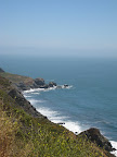
At Stinson Beach, the route meets up with Highway 1 going south. This stretch offered some spectacular views of the coast, a prelude, I'm sure, to our upcoming ride down Highway 1 in August.
The last stretch of the loop takes you along Muir Woods Road, to the Muir Woods Park area, then up, up, up again to intersect Panoramic Highway and head back to Sausalito.
According to my Topo! map, the route has a total elevation gain of 6200 feet. Now I think that the Topo software ends up tacking on extra feet depending on how you draw the map, so the total climbing is probably more in the neighbordhood of 4500-5500 feet. Although this is more climbing than I normally enjoy, it was really a spectacular route.
Update 7/15: I ended up plotting this route on Bikely.com and I came up with total elevation gain of about 5200 feet.
Distance: 42 miles
Time in the Saddle: 5 hours

1 comment:
Irode this same route on Wednesday. The climb out (yes climb out) from stinson beach is rather cruel. There's a half-way marker in the road just when you figure the thing has got to be done going up.
Post a Comment