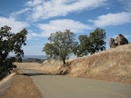
Today's ride was another variation of a ride in and around the East Bay hills. Basically there are several ways to enter the hills and several ways to exit, so there are lots of rambles possible. If I had time I'd draw up a decision tree of all the possible entrances, turns, and exits. That would be really cool.
Anyway, today's route enters the Berkeley hills via Spruce Avenue, travels through Tilden Park to Orinda and Moraga, then into the Oakland Hills and along the ridgeline to Castro Valley. From Castro Valley I had planned on circling by Lake Chabot, but Lake Chabot Road was closed for "tree disposal". So I had to take a detour that was significantly less scenic but with the same end point: San Leandro BART station.
Animules: None! Hiberation?
Total Distance: 40 miles
Total Time in the Saddle: 3.5 hours
Total Elevation gain: about 3700 feet
Bikely.com route map: East Bay Hills Ramble 3
Sunday, November 25, 2007
Thursday, November 22, 2007
Mt Diablo lite (35 miles)
This morning, pre-turkey, I rode out to Danville and up to the rangers station on Mt Diablo. I had planned to go all the way up to the summit today, but it was windy and cold.. I think it was only in the 40s most of the morning, and I really started feeling the elements out there today. Even though it was cold, it was crystal clear and beautiful up on the mountain. The streets were deserted, but there were lots of cyclists riding up Diablo... everyone cleaning out their systems in anticipation of Thanksgiving feasts?
Sunday, November 18, 2007
Maui County Bicycle Map
While researching a bicyle touring vacation in Maui, I came across this Maui County Bicycle Map, which is kinda nice. It shows suggested routes around the island as well as some elevation profiles for some routes (including directional tradewinds).
Maui Bicycle Map
Unfortunately this online version is low-res, so I can't make out the elevation marks. Paia to Hana: does that max out at 1400 or 3400 feet or 5000 something? Inquiring minds want to know!
Maui Bicycle Map
Unfortunately this online version is low-res, so I can't make out the elevation marks. Paia to Hana: does that max out at 1400 or 3400 feet or 5000 something? Inquiring minds want to know!
Monday, November 12, 2007
Hike: Palomarin to Alamere Falls (7.5 miles)
We're fortunate in the bay area to have amazing natural environments right at our door step, and there are tons of hikes and nature walks available to explore all kinds of different terrain. Today's hike was a 7.5 mile out and back through the Point Reyes reserve, terminating in a waterfall pouring into the Pacific Ocean.
Bay Area Hiker has a good write up on this hike, which starts at the Palomarin trailhead, in the Point Reyes National Seashore. Point Reyes is a really interesting nature reserve, with lots of diverse ecosystems. The Point Reyes promontory has been migrating north over the last millions of years-- it used to be directly off the Monterey bay coast-- and the movement is somehow related to the San Andreas Fault, which separates the point from the coastal mainland. I wonder if this accounts for some of the diversity of the landscape.
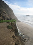 The hike follows the California Coastal Trail, and skirts several interesting coastal lakes before arriving at a junction with an unmaintained trail out to Alamere Falls, a nice tidefall. To get down to where the cascades hit the beach, there are a couple of pretty tricky scambles. I did the first one without any problem but then chickened out on the second. That's ok, even from the plateau 40 feet above the beach, the waterfall and scenery were really beautiful.
Round trip the hike took about 4 hours, including a significant break to allow for frolic time at the beach.
Bay Area Hiker has a good write up on this hike, which starts at the Palomarin trailhead, in the Point Reyes National Seashore. Point Reyes is a really interesting nature reserve, with lots of diverse ecosystems. The Point Reyes promontory has been migrating north over the last millions of years-- it used to be directly off the Monterey bay coast-- and the movement is somehow related to the San Andreas Fault, which separates the point from the coastal mainland. I wonder if this accounts for some of the diversity of the landscape.
The hike follows the California Coastal Trail, and skirts several interesting coastal lakes before arriving at a junction with an unmaintained trail out to Alamere Falls, a nice tidefall. To get down to where the cascades hit the beach, there are a couple of pretty tricky scambles. I did the first one without any problem but then chickened out on the second. That's ok, even from the plateau 40 feet above the beach, the waterfall and scenery were really beautiful.Round trip the hike took about 4 hours, including a significant break to allow for frolic time at the beach.
Sunday, November 11, 2007
Morgan Territory Loop (54 miles)
I've been meaning to do this ride for a while, and have just been waiting for the weather to cooperate. Today the conditions were perfect: we had a brief rainstorm move through Friday and Saturday, but it cleared up early Sunday morning. So it was sunny and dry, but cool. A perfect day for tackling a challenge like Morgan Territory.
Morgan Territory Road is a scenic country road that skirts the eastern side of Mt Diablo, and passes through the Morgan Territory Regional Reserve. The area is named for Jeremiah Morgan, who claimed the entire area as his own in the 1850s. While this road doesn't ascend Diablo itself, it does take you up to about 2000 feet, and the road in some parts is quite steep. So it's definitely not a gimme.
The loop begins and ends at Walnut Creek BART. The Oakland Yellow Jackets have a great turn-by-turn routesheet (pdf) that I more or less followed for this ride.
About 10 miles into the ride you'll pass through the town of Clayton-- first you'll hit the standard suburban sprawl portion of town, then the quaint old downtown area. Clayton is a good place to stop for food and drinks (lots of supermarkets and eateries, and I spotted a Peete's at mile 9.6), or you can make a pitstop at a nice park on Marsh Creek Road called Clayton Community Park. Restrooms and drinking fountains available here.
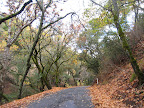 Marsh Creek Road has a lot of auto traffic and not much shoulder, but once I turned onto Morgan Territory Road, the traffic completely disappeared. In 9 miles I passed maybe 5 cars, and surprisingly didn't see any other cyclists. Weird. I had heard that Morgan Territory had lots of steep sections, but the first 6 miles were very gentle. I thought, Hey, this is easy! Then came the last 2-3 miles with lots of nasty steep climbing, but at least there were some stretches of more gentle grade to recover, and lots of shading for sun protection. This stretch of the road was heavily wooded, with oaks and.. other trees (despite that high school biology project that involved collecting all those tree leaves, they still all look the same to me). It almost reminded me of some of the scenery in New Jersey. Maybe my east coast readers will see the pics and disagree.
Just before the summit (around 2000 feet) is the Morgan Territory Reserve staging area, with pit toilets and not much else. There was a large orienteering group at the staging area while I was there. That always looks like fun to me; I should look into that and see what the deal is. Past the summit, you begin the descent into the Livermore valley area. It's really striking how quickly the scenery changes at this point. All of that shaded, wooded reserve gives way to arrid grazing hills that are bone-dry this time of year.
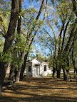
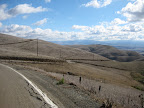 It was like turning a corner and finding yourself on another planet. It's a nice descent though: not technical at all, just a straight, fast shot down to the valley. Once there, the route follows Highland Road and Camino Tassajara (part of the Cinderella Century route-- beware the headwinds!) to return to Danville. Oh, and on Finley Road you have to check out the old Tassajara School, dating to 1889. Quaint!
From Danville it's a straight shot up Danville Blvd to the BART station.
Animules: one llama, many horses, some cows, three deer, lots of hawks
Total Distance: 54 miles
Elevation gain: about 3000 feet
Time in the Saddle: 5 hours
Route (on bikely.com): Morgan Territory Loop
Morgan Territory Road is a scenic country road that skirts the eastern side of Mt Diablo, and passes through the Morgan Territory Regional Reserve. The area is named for Jeremiah Morgan, who claimed the entire area as his own in the 1850s. While this road doesn't ascend Diablo itself, it does take you up to about 2000 feet, and the road in some parts is quite steep. So it's definitely not a gimme.
The loop begins and ends at Walnut Creek BART. The Oakland Yellow Jackets have a great turn-by-turn routesheet (pdf) that I more or less followed for this ride.
About 10 miles into the ride you'll pass through the town of Clayton-- first you'll hit the standard suburban sprawl portion of town, then the quaint old downtown area. Clayton is a good place to stop for food and drinks (lots of supermarkets and eateries, and I spotted a Peete's at mile 9.6), or you can make a pitstop at a nice park on Marsh Creek Road called Clayton Community Park. Restrooms and drinking fountains available here.
Marsh Creek Road has a lot of auto traffic and not much shoulder, but once I turned onto Morgan Territory Road, the traffic completely disappeared. In 9 miles I passed maybe 5 cars, and surprisingly didn't see any other cyclists. Weird. I had heard that Morgan Territory had lots of steep sections, but the first 6 miles were very gentle. I thought, Hey, this is easy! Then came the last 2-3 miles with lots of nasty steep climbing, but at least there were some stretches of more gentle grade to recover, and lots of shading for sun protection. This stretch of the road was heavily wooded, with oaks and.. other trees (despite that high school biology project that involved collecting all those tree leaves, they still all look the same to me). It almost reminded me of some of the scenery in New Jersey. Maybe my east coast readers will see the pics and disagree.Just before the summit (around 2000 feet) is the Morgan Territory Reserve staging area, with pit toilets and not much else. There was a large orienteering group at the staging area while I was there. That always looks like fun to me; I should look into that and see what the deal is. Past the summit, you begin the descent into the Livermore valley area. It's really striking how quickly the scenery changes at this point. All of that shaded, wooded reserve gives way to arrid grazing hills that are bone-dry this time of year.
It was like turning a corner and finding yourself on another planet. It's a nice descent though: not technical at all, just a straight, fast shot down to the valley. Once there, the route follows Highland Road and Camino Tassajara (part of the Cinderella Century route-- beware the headwinds!) to return to Danville. Oh, and on Finley Road you have to check out the old Tassajara School, dating to 1889. Quaint!From Danville it's a straight shot up Danville Blvd to the BART station.
Animules: one llama, many horses, some cows, three deer, lots of hawks
Total Distance: 54 miles
Elevation gain: about 3000 feet
Time in the Saddle: 5 hours
Route (on bikely.com): Morgan Territory Loop
Monday, November 5, 2007
Good eats: Cab-braised short ribs
One of the things I like to do after a long ride is prepare (and consume) a really nice meal. I don't know why, but almost any food is extra tasty after a long, hard ride. When I come across a particularly tasty post-ride meal, I'll post the recipe here.
This past Sunday, after coming very close to getting to the summit of Mt. Diablo, I treated myself to cabernet-braised short ribs, roasted red and sweet potatoes, and roasted brussel sprouts. For the short rib preparation, I essentially followed the recipe at Bon Appetit. This is really pretty simple:
First, you want to season the short ribs a day in advance and just put them in the fridge over night. Lay the ribs (I had about 2.5 lbs of them) in a glass pan and sprinkle generously with a mixture of kosher salt, pepper, fresh thyme, and fresh rosemary (about 1 tbsp of each). Cover and chill overnight.
To continue-- heat some olive oil in a heavy pan over medium heat and brown the short ribs, about 6-8 minutes on each side. Transfer ribs to a plate and drain off the oil from the pan. Next pour a full bottle of Cab (I just used two buck Chuck) into the pan and bring to a boil, scraping up any browned bits on the pan. I added some vegetable stock at this point too, just for kicks. Return the ribs to the pan, reduce the heat to a low simmer, cover, and let it cook for a good hour and 15 if not more. Note that Bon Appetit calls for this to braise in the oven but since I don't have a suitable dutch oven I prepared this entirely on the stove top.
While the ribs are simmering away, cut up some new red potatoes and small sweet potatoes into chunks, toss with olive oil, thyme, and rosemary, and place in a single layer in a parchment-lined baking dish. Put these into the oven (350-375) about 45 minutes before you're planning on serving dinner. After that, clean some brussel sprouts, cut in half, and similarly toss in a bit of olive oil, thyme, and rosemary. Place these, cut side down, in another parchment-lined baking dish. These will only take 15-20 minutes to roast, so put them in last.
Now, when your short ribs are tender, remove them from the braising sauce and set aside, covered with foil to keep them warm. To thicken the wine sauce, combine 1 tbsp butter and 1 tbsp flour in a small bowl, combine into a paste, and then whisk into the simmering wine sauce until it thickens. The sauce should be well-seasoned already, but you can add more salt/pepper if desired.
Serve the short ribs with the sauce drizzled on top and the potatoes and brussel sprouts on the side. Don't forget to open another bottle of Cab to drink along with the ribs.
Sunday, November 4, 2007
Lafayette-Mt. Diablo Loop (42.5 miles)
Today I came this close to making it up to the summit of Mt. Diablo. Even though I didn't make it up there today, I did go farther up than on my last trip, and I'm pretty sure that next time I'll be able to get my ass up to the top without too much trouble.
Like last time, I began at Lafayette BART station, which gives me a nice warm-up of 12-13 miles before starting the real climb. Unfortunately I again consumed 4 cups of java before heading out and again had trouble finding a restroom before hitting the mountain. Last time I passed up a porta-potty at a park that was under construction, in the hopes of finding a better option (yes that was stupid). This time I stopped at that park and the construction is finished, so no more porta-potty. Argh. Luckily they are doing some re-paving at the Athenian School at the base of Diablo, so there's a pit toilet there for now. But I really need to map out some better break spots, because I feel like I'm at the mercy of the construction crews in the San Ramon valley.
I wasn't really feeling 100% today, and it was pretty warm up on the mountain... probably around 75 degrees, which is too goddamn hot for November if you ask me. So I think it took me a bit longer to get up to the rangers station. At that point I took the turn up Summit Road for the first time ever. I was expecting it to be harsh, because it's supposed to be much steeper than either approach to the rangers station. But actually it really wasn't too bad. From the rangers station to the summit is 4.5 miles, and I made it up to Juniper campground, 3000 ft and 2 miles from the summit, when I ran out of water. And, because this is the kind of luck I have, none of the water spigots are working on the mountain right now. Apparently they've turned off all the water because they're low. Fair enough, but still... it's a problem if you're out there and dehydrated, no? At the campground I ran into a park ranger, Sam, who gave me one of his extra water bottles. Thanks Sam! Since I was already a bit dehydrated, I didn't want to push it, so that's when I decided to head back down. Next time I'll hydrate better and bring extra water.
 Heading back down North Gate was pleasant.. I stopped to take a few pics along the way. Instead of finishing up at Pleasant Hill BART I looped back over to Lafayette for a quick BART ride home.
Animules: horses, one dead squirrel
Total Distance: 42.5 miles
Elevation gain: about 3000 feet
Time in the Saddle: 4 hours
Route (on bikely.com): Lafayette-Mt. Diablo
Like last time, I began at Lafayette BART station, which gives me a nice warm-up of 12-13 miles before starting the real climb. Unfortunately I again consumed 4 cups of java before heading out and again had trouble finding a restroom before hitting the mountain. Last time I passed up a porta-potty at a park that was under construction, in the hopes of finding a better option (yes that was stupid). This time I stopped at that park and the construction is finished, so no more porta-potty. Argh. Luckily they are doing some re-paving at the Athenian School at the base of Diablo, so there's a pit toilet there for now. But I really need to map out some better break spots, because I feel like I'm at the mercy of the construction crews in the San Ramon valley.
I wasn't really feeling 100% today, and it was pretty warm up on the mountain... probably around 75 degrees, which is too goddamn hot for November if you ask me. So I think it took me a bit longer to get up to the rangers station. At that point I took the turn up Summit Road for the first time ever. I was expecting it to be harsh, because it's supposed to be much steeper than either approach to the rangers station. But actually it really wasn't too bad. From the rangers station to the summit is 4.5 miles, and I made it up to Juniper campground, 3000 ft and 2 miles from the summit, when I ran out of water. And, because this is the kind of luck I have, none of the water spigots are working on the mountain right now. Apparently they've turned off all the water because they're low. Fair enough, but still... it's a problem if you're out there and dehydrated, no? At the campground I ran into a park ranger, Sam, who gave me one of his extra water bottles. Thanks Sam! Since I was already a bit dehydrated, I didn't want to push it, so that's when I decided to head back down. Next time I'll hydrate better and bring extra water.
Heading back down North Gate was pleasant.. I stopped to take a few pics along the way. Instead of finishing up at Pleasant Hill BART I looped back over to Lafayette for a quick BART ride home. Animules: horses, one dead squirrel
Total Distance: 42.5 miles
Elevation gain: about 3000 feet
Time in the Saddle: 4 hours
Route (on bikely.com): Lafayette-Mt. Diablo
Subscribe to:
Posts (Atom)
