August was good. Thanks to the ride down the coast, I logged over 500 miles in the month, a first ever.
August mileage: 516
August Time in the Saddle: 47 hours
Friday, August 31, 2007
Sunday, August 26, 2007
East Bay Trails (CFGFC lite)
This weekend I decided to do a shorter, modified version of the CFGFC route, for two reasons: a) I wanted to proof the route to make sure nothing had changed since last year (construction, road closures, etc.) and b) I wanted to try some different routes for the last 30 miles between Fremont and Oakland.
Basically the first 70 miles of the CFGFC are great. You've got the Oakland hills, the San Ramon Valley, a few nice multi-use trails, good road conditions, and nice scenery. The problem is the final leg between Fremont and Oakland, or at least the stretch between Fremont and San Leandro. It's basically a wasteland of industrial parkways, ghettos, and barrios, sprinkled with the occasional stripmall. It's a bit depressing, if not dangerous in some spots. So, each year I hit the road in search of a better route. I like to think of it as my own search for a Northwest Passage. Anyway, today's effort was not wholly successful, but I did find some new and interesting multi-use trails that I'll probably incorporate into the CFGFC. So we'll call this ride the East Bay Trail Excursion.
This ride began at Orinda BART station, traveled south through San Ramon valley, west through Niles Canyon, and then north more or less along the bay to end at Fruitvale BART. Notable trails used on the ride include:
Lafayette Moraga Trail and Iron Horse Trail: my two readers will recognize these trails from previous rides. Both are well graded, scenic, and high quality.
Alameda Creek Trail: This trail runs alongside the Alameda Creek, from Niles Canyon all the way to the bay. The trail along the southern bank is paved for cyclists and what have you; the trail along the northern bank is dirt and gravel for horses and people who like dirt. It's not as pretty as the Iron Horse or the other trails in the San Ramon valley, but it's pretty nice for Fremont and Union City.
Union City Trail: This is a strange, hidden little multi-use trail I stumbled upon in Union City. This one is deep undercover people: there aren't even any websites that describe it. Think on that. The good part about it is that it's not busy at all (in fact it was empty). The bad part is that it might be abandoned? I couldn't tell. There seemed to be a lot of obstacles to actually using the trail, like closed gates and a section with open, raised railroad tracks, so I'm wondering if this trail is officially in use. It was a bit creepy.. I had a thought that someone could disappear on this trail and no one would ever know. So, it's definitely going into the CFGFC route.
Bay Trail from San Leandro to Marina Park: This is part of the "Bay Trail" that will someday (!) encircle the entire bay with over 400 miles of continuous multi-use trails. Won't that be awesome?! It will totally solve my northwest passage issue. But until it's completed (date unknown), we have to make due with these small pieces of the trail. This one runs just a few miles right along the bay in San Leandro. The water is so close here, just a small global warming hiccup would easily flood the path. The headwinds are a bitch traveling north along the water, but the scenery is worth it.
Distance: 75 miles
Time in the Saddle: about 6.5 hours
Elevation Gain: 1370 feet
Route: East bay trails
Monday, August 20, 2007
cfgfc 2007 logo
I've been working on the logo for the 2007 cfg fall century.. here's what I have so far:


Gear ratios
For most of June and July I spent a lot of my saddle time on the Terry touring bike, in preparation for the coastal ride. The Terry has mountain-bike gearing more or less: a standard triple up front (52-42-30) with a 9 speed 11-32t cassette in back. So with the 30-32 combination, you have a decent granny gear to get you up most hills.
This weekend I took the Dolce out for the Holstein Hundred, and I had completely forgotten how different the gear ratios are on this bike. I definitely felt it on every climb. When I got back home I started counting, and soon realized that, although the triple in front is the same, the Dolce has a 12-25 cassette as opposed to the 11-32 on the Terry. Huge difference! So on Sunday I took a quick trip over to Alameda Bicycle and ordered a new 11-28 cassette. This will give me the same gears on the Specialized that I have on the Terry, with the exception of that lowest granny gear (the 32). I can't wait to get it installed and try it out on the nearest hill.
This weekend I took the Dolce out for the Holstein Hundred, and I had completely forgotten how different the gear ratios are on this bike. I definitely felt it on every climb. When I got back home I started counting, and soon realized that, although the triple in front is the same, the Dolce has a 12-25 cassette as opposed to the 11-32 on the Terry. Huge difference! So on Sunday I took a quick trip over to Alameda Bicycle and ordered a new 11-28 cassette. This will give me the same gears on the Specialized that I have on the Terry, with the exception of that lowest granny gear (the 32). I can't wait to get it installed and try it out on the nearest hill.
Saturday, August 18, 2007
Holstein Hundred, more or less
Today was the 14th annual Holstein Hundred century, which begins and ends in the tiny town of Tamales and does a couple of strangely-designed loops through Bodega Bay, Occidental, Valley Ford, and the general countryside around Petaluma. I had planned on doing the full century, but in the end I only did a metric. Not their metric, but a metric nonetheless. There are many reasons for this, but mostly I think it's the ride organizers' fault for giving me an easy out.
I woke up at 5am to drive up to Tamales, got there by 6:30, and was on the road by 7. One thing we lucked out on was the weather: it was sunny and clear, no marine layer at all. This was especially nice when we got out to the coast near Bodega Bay (where Hitchcock filmed The Birds if you didn't know). It's always nice to actually see the ocean when you're riding on the coast, as opposed to peering into a deep fog bank. Things were going quite nicely through the first 20 miles or so, until we turned inland again and began a climb up Coleman Valley Road.
I've never climbed this road before, and come to think of it, I didn't really climb it this time because I had to walk my bike up half of it. It's only about 1200 feet or so, but it's steep almost the entire way. Someone on the internets claimed that the grade was 9.5%, which is about 5% more grade than I generally enjoy. This climb was featured in one of the Tour of California stages, and it does afford some lovely views which I was able to appreciate during my long walk up to the summit.
Once we got passed this climb, the route mellowed out a bit and took us through parts of Occidental and Valley Ford that I had traversed on my Petaluma ride back in May. At this point I ended up latching on to some women from Livermore who had a little paceline going. I pulled for a while and they invited me to ride with them, but honestly their pace ended up being too much for me. They were going about 25 mph, and I just couldn't sustain that, even hooked on to the back.
At about mile 45 we turned west and that's when the headwinds began. Those lasted for about 10 miles until the route took us east again, past the starting point at Tamales High. I mentioned the strange loops that comprised the route.. basically we did a big figure eight, then passed by the starting point before beginning another loop to the south. Earlier in the morning I had thought, I can stop by my car to deposit my arm warmers, leg warmers, etc. But then after all the climbing and headwinds, and with the knowledge that another 40 miles and 3500 feet of climbing lay ahead, I was thinking, I can stop by my car, have some lunch, and call it a day! You see how this is really the organizers' fault? Because let me tell you, I wasn't the only one who had this thought. At any rate, I actually continued on a few miles passed the high school, spotted the next climb, and then backtracked to the start. So, I ended up with about 65 miles total. I'm sure I could have finished the course, but I don't think I would have enjoyed it. And as one of the volunteers said at the post-ride lunch, It's supposed to be fun, not torture.
Miles: 65
Time in the saddle: about 5 hours
Route for the Holstein Hundred: portion done and portion not done
Friday, August 10, 2007
SF-SLO Tour, Day 5
Day 5: San Simeon to San Luis Obispo(route), 43 miles
Total time in the saddle: 4 hours 15 minutes
Elevation gain: 1800 feet
After the challenges of day 4, the relatively short, flat route of the final day was a welcome sight. And although it wasn't as scenic as the previous days along the coastal cliffs, there was still plenty of interesting scenery. Just a few miles outside of San Simeon, we traveled through a cute little beach village called Moonstone Beach and then through Cambria. Past Cambria the route took us a bit inland for the next 10 miles or so, and we didn't see the ocean again until Cayucos, another cute beach town.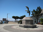
A few miles down the coast we stopped for lunch at Morro Bay. I had been feeling sluggish and dehydrated in the morning, but felt revived after lunch. In contrast, kc had been feeling pretty good up until Morro Bay, but then he ended up seriously bonking the final 15 miles to San Luis Obispo.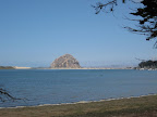
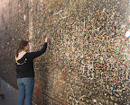
Once we arrived in SLO, kc crashed out for a few hours while I explored the quaint downtown area. Later that evening, while investigating dinner options, we ended up stumbling upon this wall downtown covered in bubble gum. Disgusting!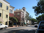
For my part, it was a great end to a great tour down the coast. I only wish I had been able to continue a few more days down to Santa Barbara, but alas I had to return to work. Next year I think I'll be ready for something even more challenging.
Total time in the saddle: 4 hours 15 minutes
Elevation gain: 1800 feet
After the challenges of day 4, the relatively short, flat route of the final day was a welcome sight. And although it wasn't as scenic as the previous days along the coastal cliffs, there was still plenty of interesting scenery. Just a few miles outside of San Simeon, we traveled through a cute little beach village called Moonstone Beach and then through Cambria. Past Cambria the route took us a bit inland for the next 10 miles or so, and we didn't see the ocean again until Cayucos, another cute beach town.
A few miles down the coast we stopped for lunch at Morro Bay. I had been feeling sluggish and dehydrated in the morning, but felt revived after lunch. In contrast, kc had been feeling pretty good up until Morro Bay, but then he ended up seriously bonking the final 15 miles to San Luis Obispo.
Once we arrived in SLO, kc crashed out for a few hours while I explored the quaint downtown area. Later that evening, while investigating dinner options, we ended up stumbling upon this wall downtown covered in bubble gum. Disgusting!
For my part, it was a great end to a great tour down the coast. I only wish I had been able to continue a few more days down to Santa Barbara, but alas I had to return to work. Next year I think I'll be ready for something even more challenging.
Thursday, August 9, 2007
SF-SLO Tour, Day 4
Day 4: Big Sur to San Simeon (route), 67 miles
Total time in the saddle: 7 hours
Elevation gain: 6500 feet
At 67 miles with plenty of steep climbing, we knew that the stage from Big Sur to San Simeon was going to be a "long hard day", to quote from my Lonely Planet west coast cycling book. A part of me was looking forward to the challenge, while I think all of kc was dreading the pain it would entail.
Side note: my boss' boss' boss, a hard core cyclist, maintains that you have to be a bit of a masochist to love cycling. I suppose this is true, but I don't think that kc has reached the point where he has embraced the pain.
Anyway, because we had our printed cue sheets and elevation profiles with us, we knew that right out of the gate we'd have a climb up to 1000 ft. kc decided to leave Big Sur a bit earlier and walk up that first climb, in order to conserve his energy. I would leave a bit later and meet him 7 miles south of Big Sur, at the "cafe" at Coast Gallery. I was checked out of the campgrounds and on the machine by 8:45, and while the climb was a bit steep in places, it was manageable. At Coast Gallery I found kc waiting for me but still sans coffee. Turns out the cafe noted in my guide book had closed two years back. Oops.
Between Coast Gallery and Lucia, the next stop with services (mile 25), there was nothing but coastline and constant ups and downs. Along the way we did stop at McWay falls, which is the only waterfall in California that falls directly into the ocean (or beach at low tide, apparently). Kc noted that it was like the "Earth is pissing".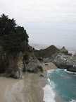
We stopped at Lucia, which is little more than a very expensive restaurant and general store along the highway, but it's pretty much the only stop along a 25 mile stretch, so there were plenty of tourists also taking a break there. We got drinks and ate the last of our soggy 2 day old PB&J sandwiches we had made in Monterey (blech), and met a couple of folks also touring along highway 1. They were heading back home to Redondo Beach, but were going to stop and camp just a few miles up the road.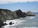
After Lucia, it was more rolling hills until we reach the next village on the highway, Gorda. Like Lucia, Gorda is basically just a restaurant, cafe, and general store, but it has a little more character than Lucia, and we spent about 45 minutes just relaxing and chatting with some of the characters hanging out there, and contemplating the two climbs we had to look forward to.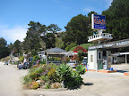
Besides the initial climb of the day and the undulations of miles 5-35, there were two principal climbs between miles 40-45. Lonely Planet classified one as "moderate" and the other as "steep", and early in the day kc had taken to calling them los cuernos del diablo (the devil's horns). After a quick descent south of Gorda, the climbing began. We conquered the first cuerno, took a breather, and then took on the much steeper second peak and conquered that one as well. Victory! After that it was screaming descent past Ragged Point, then onto flatter terrain outside of San Simeon. We arrived at the motel at 6:40pm, 10 hours after I had left Big Sur. Good times!
Wednesday, August 8, 2007
SF-SLO Tour, Day 3
Day 3: Monterey to Big Sur (route), 40 miles
Total time in the saddle: 4 hours
Elevation gain: 4900 feet
We got a fairly early start on Day 3, and were on the bikes by 9:30. Just south of Monterey, we cruised along the 17 mile scenic drive, which was picturesque but a bit dismal with the heavy marine layer.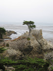
We had quick pitstops at both Carmel and Carmel Highlands, where we loaded up on supplies at the Carmel Highlands General Store. Outside the store I chatted with a woman (a Carmel Highlands firefighter?) about the 500 mile AIDS ride down the coast. She had done the ride the previous two years and was trying to talk me into it, but the mileage sounded excruciating: 80-90 miles each day. Crazy.
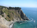
The next 10 miles were classic rugged coastline, with highway 1 winding up and down, hugging the cliffs. In places there was little to no shoulder and quite a bit of traffic, so that was a bit sketchy. Still, it was beautiful ride, and a taste of what was to come on day 4.
The last 10 miles or so took us inland a bit, through pastures and grazing cows, until we started climbing gently into the redwood forests of Big Sur. There we had reserved a tent cabin at Big Sur Campground and Cabins.
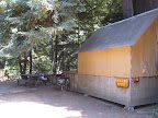
It was rustic but clean and blessedly free of mosquitos. After a quick survey of the handful of restaurants along the highway, we settled on the Maiden Pub in Big Sur Village. This turned out to be my favorite restaurant of the whole trip.. I highly recommend the burgers there. Deelish.
Total time in the saddle: 4 hours
Elevation gain: 4900 feet
We got a fairly early start on Day 3, and were on the bikes by 9:30. Just south of Monterey, we cruised along the 17 mile scenic drive, which was picturesque but a bit dismal with the heavy marine layer.
We had quick pitstops at both Carmel and Carmel Highlands, where we loaded up on supplies at the Carmel Highlands General Store. Outside the store I chatted with a woman (a Carmel Highlands firefighter?) about the 500 mile AIDS ride down the coast. She had done the ride the previous two years and was trying to talk me into it, but the mileage sounded excruciating: 80-90 miles each day. Crazy.
The next 10 miles were classic rugged coastline, with highway 1 winding up and down, hugging the cliffs. In places there was little to no shoulder and quite a bit of traffic, so that was a bit sketchy. Still, it was beautiful ride, and a taste of what was to come on day 4.
The last 10 miles or so took us inland a bit, through pastures and grazing cows, until we started climbing gently into the redwood forests of Big Sur. There we had reserved a tent cabin at Big Sur Campground and Cabins.
It was rustic but clean and blessedly free of mosquitos. After a quick survey of the handful of restaurants along the highway, we settled on the Maiden Pub in Big Sur Village. This turned out to be my favorite restaurant of the whole trip.. I highly recommend the burgers there. Deelish.
SF-SLO Tour, Day 2
Day 2: Santa Cruz to Monterey (route), 48.2 miles
Total time in the saddle: 4.5 hours
Elevation gain: 1800 feet
The morning of Day 2 began with a quick trip to the drug store to pick up the items we needed to recover from Day 1. For me that meant super power sunscreen and a bandana; for kc it was ace bandages, muscle ointments, and generally things that smelled like menthol.
South of Santa Cruz, Highway 1 is a semi-freeway with bicycle traffic prohibited, so the route took us along side streets through the outskirts of town and out through rural agricultural land. Although we were probably never further than a mile or two away from the coastline, we didn't see the ocean for most of the day. Instead we traveled along side fragrant strawberry fields, patches of lettuce and other veggies, and the like.
While stopping for sandwiches and coffee in the village of Marina we ran into a gaggle of small town cheerleaders. It took the barista 15 minutes to make my single espresso because every one of those cheerleaders had ordered a double half-caff carmel mochiatto frappucino, or something similar. Terrifying.
A few miles north of Monterey, we picked up a nice multi-use trail that led us back to the coastline. This part of the coast was dominated by huge sand dunes and the ubiquitous Monterey cypress.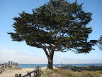
We arrived at the Monterey hostel a little after 5 o'clock. The hostel is more traditional than the Carmelita cottages in Santa Cruz, but the facility was super clean and the location couldn't be beat. We were just blocks away from Cannery Row, so we strolled down to the waterfront for dinner at a pub called Bullwacker's. I believe that everything we ate at that place was deep-fried. It tasted pretty good, but didn't sit too well with either of us that night.
Tuesday, August 7, 2007
SF-SLO Tour, Day 1
The mission: to bicycle from San Francisco (okay, Half Moon Bay) to San Luis Obispo; 250 miles in 5 days. Along the way we would experience ups and downs, cold marine layers and glorious sunshine, small town coffee, and questionable fish and chips. But we made it! Read on to see how the journey unfolded...
Day 1: Half Moon Bay to Santa Cruz (route), 50 miles
Total time in the saddle: 4.5 hours
Elevation gain: 2400 feet
Getting there: From the beginning I knew that I wanted to start the first day a bit outside of San Francisco, both to reduce the mileage a bit and to avoid the particulary sketchy stretches of highway 1 around Devil's Slide (south of Pacifica). So after waking up early to catch BART into the city, I met up with kc and took Caltrain down the peninsula to Hillsdale. Caltrain is well-equipped to handle bicycles, so it's a great choice for cyclists. At Hillsdale, we loaded the bikes onto the SamTrans bus (route 294) and headed to Half Moon Bay. Naturally, a car accident slowed traffic on highway 92 to a crawl, so we didn't actually start riding until 11:30.
By the time we hit the road, the morning marine layer had cleared and we had fabulous weather the entire way to Santa Cruz. Along the way we stopped at several state beaches, including San Gregorio and Pebble Beach. This isn't the Pebble Beach famous for golf (that's later on day 3) but rather a small beach near Pescadero that features interesting rock formations and abundant tide pools.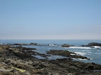
After stopping at the roadside Gazo's Grill for lunch, we took some time to explore the terrain around Pigeon Point Lighthouse. Then it was on through Davenport to Santa Cruz. Outside of town we picked up a nice multi-use trail that took us by Natural Bridges park, which didn't really look like a natural bridge from our angle. Weird.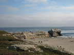
In Santa Cruz we had reserved a private room at the Carmelita Cottages hostel.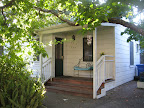 This was my first foray into hostel accommodations, and I must say that I was impressed. The cottages were really quaint, perfectly situated within walking distance of both downtown and the boardwalk, and sharing a bathroom with a French (Swiss?) couple wasn't really all that bad.
We trolled the downtown stretch for a while before settling on Saturn Cafe for dinner. Although the window advertised "Burgers, Fries" etc. it turned out that the place was strictly vegetarian and vegan. I would say that their window advertising and menu really bury the lede on that, but the food was pretty decent all the same. After dinner we strolled down to the Santa Cruz Beach boardwalk and rode the "Tsunami" ride. A pretty good first day on the road.
Day 1: Half Moon Bay to Santa Cruz (route), 50 miles
Total time in the saddle: 4.5 hours
Elevation gain: 2400 feet
Getting there: From the beginning I knew that I wanted to start the first day a bit outside of San Francisco, both to reduce the mileage a bit and to avoid the particulary sketchy stretches of highway 1 around Devil's Slide (south of Pacifica). So after waking up early to catch BART into the city, I met up with kc and took Caltrain down the peninsula to Hillsdale. Caltrain is well-equipped to handle bicycles, so it's a great choice for cyclists. At Hillsdale, we loaded the bikes onto the SamTrans bus (route 294) and headed to Half Moon Bay. Naturally, a car accident slowed traffic on highway 92 to a crawl, so we didn't actually start riding until 11:30.
By the time we hit the road, the morning marine layer had cleared and we had fabulous weather the entire way to Santa Cruz. Along the way we stopped at several state beaches, including San Gregorio and Pebble Beach. This isn't the Pebble Beach famous for golf (that's later on day 3) but rather a small beach near Pescadero that features interesting rock formations and abundant tide pools.
After stopping at the roadside Gazo's Grill for lunch, we took some time to explore the terrain around Pigeon Point Lighthouse. Then it was on through Davenport to Santa Cruz. Outside of town we picked up a nice multi-use trail that took us by Natural Bridges park, which didn't really look like a natural bridge from our angle. Weird.
In Santa Cruz we had reserved a private room at the Carmelita Cottages hostel.
This was my first foray into hostel accommodations, and I must say that I was impressed. The cottages were really quaint, perfectly situated within walking distance of both downtown and the boardwalk, and sharing a bathroom with a French (Swiss?) couple wasn't really all that bad. We trolled the downtown stretch for a while before settling on Saturn Cafe for dinner. Although the window advertised "Burgers, Fries" etc. it turned out that the place was strictly vegetarian and vegan. I would say that their window advertising and menu really bury the lede on that, but the food was pretty decent all the same. After dinner we strolled down to the Santa Cruz Beach boardwalk and rode the "Tsunami" ride. A pretty good first day on the road.
Thursday, August 2, 2007
Subscribe to:
Posts (Atom)
