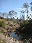
Finally! Back in late September I made my second ever trek up Diablo, to the rangers station, and said blithely, "Next time I'll either try to improve [on my time] or try for the summit". Heh. Then there were the two attempts in November and one in December where I actually got pretty close but was turned back by the lousy conditions. So, fifth time's a charm.
Rather than starting at BART, I decided to drive and park in Danville, to reduce the pre-climbing mileage a bit. I parked at the newly renovated Oak Hill Park on Stone Valley Road, which has an amazing, brand-new public bathroom. We'll see how long that lasts.
The weather at the base of the mountain was overcast but relatively mild, probably low to mid-50s with very little wind. I broke through the cloud cover just past the ranger station, on my way up Summit Road. Above the inversion layer, the conditions were great. Sunny and deceptively warm. A cyclist in a short-sleeved jersey passed by as he was descending, fast, and a fellow climber said, "That guy is gonna freeze his nipples off!"
Summit Road is definitely steeper than the roads leading up to it, but there are only two sections, each about a mile long, where I struggled. I was going pretty slow, 3-4 miles an hour at most, but then about a mile from the top, there's a switchback and the road suddenly evens out a bit. What a relief. The final 400 foot approach to the observatory is a 16% grade, so I hoofed it up that part. But still, with the comfortable spring conditions, it really wasn't that bad.
That's two peaks down, and one to go. Mt Tam, here I come.
Monday, February 18, 2008
Sunday, February 17, 2008
Lake Berryessa Loop (40 miles)
If I had had my druthers (and a smaller credit card balance) I would have headed up to Calistoga for the long President's Day weekend. The next best thing is to fire up the ol' Toyota and head up to wine country for a day ride. This particular ride starts and ends at Lake Hennessey, just a bit north of Napa, near Rutherford. My four readers may remember that I cruised by Lake Hennessey back in September, when it was particularly low. We've had some decent rainfall this winter, so the lake seems.. full? I dunno. I should have taken a pic back in September, so we could do a side-by-side comparison. Oh well.
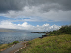
Anyway, you can park your ol' Toyota (or the vehicle of your choice) at the Lake Hennessey boat launch. There doesn't seem to be any requirement that you actually launch a boat to park here, which is good because that would have complicated matters. From the boat launch, the route travels north through Pope Valley, heads east along Pope Canyon, skirts alongside Lake Berryessa for 13 miles, then heads back to Lake Hennessey via Sage Canyon Road (highway 128). Chiles Pope Valley, Pope Canyon, and Sage Canyon Roads all traverse canyons with creeks, so even the non-lake portions of the route are quite scenic. I imagine these roads could get crowded in the summer, but today I barely saw anyone on the roads. Just a handful of cyclists, a few motorists, and some motorcycles. For large stretches I had the road entirely to myself. Whee!
 The Chiles Valley is interesting.. it's just a few miles to the east of the Napa Valley appellation area, but it's clearly a bit more arid. Apparently the fog that can settle in the Napa valley doesn't quite get past the foothills into the Chiles Valley area. In fact this morning the fog driving up through Napa was like pea soup, but it didn't penetrate past Lake Hennessey. It's another example of the microclimates that we see in California so often, where you have the coastal climate, then a small seismic ridge, then a valley, then a ridge, then another valley, all within a 20 mile radius from the ocean. The valley is named after a guy named Joseph Chiles, who got one of the land grants from the Mexican government before the US seized the territory in 1848.
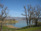
Lake Berryessa is a more recent development. Since seeing the movie Zodiac, I associate the lake with the zodiac killer, but it's not just for psychotic murders! It's also for people who like recreation, and boats, and picnics. The lake is a man-made reservoir, and was formed in the 1950s by the Monticello Dam. The decision to create the dam and flood the valley (and abandon the town of Monticello) was controversial, and documented by Dorothea Lange in her book Death of a Valley.
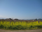 If you travel through Napa valley this time of year, you'll see lots of yellow mustard flowers covering the dormant vineyards. I wondered if these were wild flowers (tales of Junipero Serra tossing mustard seeds to the wind) but the internets tell me that the vintners plant mustard because they
stimulate the soil. Hmm.
 Of course, no visit to the area would be complete without a quick stop for winetasting/purchasing. To get to and from Lake Hennessey, you'll pass through Rutherford and be within sloshing distance of tons of wineries along Silverado Trail. I belong to the wine club at Rutherford Hill, so naturally I took the opportunity to stop by and pick up a few bottles of Cab and vintage port. When in Napa...
Total Miles: 41
Elevation Gain: 3590 ft
Animules: lots of horses and cows
Route map (bikely.com): Hennessey-Berryessa
Anyway, you can park your ol' Toyota (or the vehicle of your choice) at the Lake Hennessey boat launch. There doesn't seem to be any requirement that you actually launch a boat to park here, which is good because that would have complicated matters. From the boat launch, the route travels north through Pope Valley, heads east along Pope Canyon, skirts alongside Lake Berryessa for 13 miles, then heads back to Lake Hennessey via Sage Canyon Road (highway 128). Chiles Pope Valley, Pope Canyon, and Sage Canyon Roads all traverse canyons with creeks, so even the non-lake portions of the route are quite scenic. I imagine these roads could get crowded in the summer, but today I barely saw anyone on the roads. Just a handful of cyclists, a few motorists, and some motorcycles. For large stretches I had the road entirely to myself. Whee!
The Chiles Valley is interesting.. it's just a few miles to the east of the Napa Valley appellation area, but it's clearly a bit more arid. Apparently the fog that can settle in the Napa valley doesn't quite get past the foothills into the Chiles Valley area. In fact this morning the fog driving up through Napa was like pea soup, but it didn't penetrate past Lake Hennessey. It's another example of the microclimates that we see in California so often, where you have the coastal climate, then a small seismic ridge, then a valley, then a ridge, then another valley, all within a 20 mile radius from the ocean. The valley is named after a guy named Joseph Chiles, who got one of the land grants from the Mexican government before the US seized the territory in 1848. Lake Berryessa is a more recent development. Since seeing the movie Zodiac, I associate the lake with the zodiac killer, but it's not just for psychotic murders! It's also for people who like recreation, and boats, and picnics. The lake is a man-made reservoir, and was formed in the 1950s by the Monticello Dam. The decision to create the dam and flood the valley (and abandon the town of Monticello) was controversial, and documented by Dorothea Lange in her book Death of a Valley.
If you travel through Napa valley this time of year, you'll see lots of yellow mustard flowers covering the dormant vineyards. I wondered if these were wild flowers (tales of Junipero Serra tossing mustard seeds to the wind) but the internets tell me that the vintners plant mustard because they stimulate the soil. Hmm.
Of course, no visit to the area would be complete without a quick stop for winetasting/purchasing. To get to and from Lake Hennessey, you'll pass through Rutherford and be within sloshing distance of tons of wineries along Silverado Trail. I belong to the wine club at Rutherford Hill, so naturally I took the opportunity to stop by and pick up a few bottles of Cab and vintage port. When in Napa...Total Miles: 41
Elevation Gain: 3590 ft
Animules: lots of horses and cows
Route map (bikely.com): Hennessey-Berryessa
Sunday, February 3, 2008
Kihei Sunshine Ride (40 miles)
One lesson I learned while visiting Maui in the winter: if you want sunshine, even when the rest of the island is in a torrential downpour (or under snowcover), you need to head over to the leeward side known as "south Maui", home to the resort towns of Kihei and Wailea. The mass of Haleakala blocks most of the tradewind weather patterns, so at least you've got a shot at drying out for the day.
Originally we had planned on riding up to Hana from Paia, but after dealing with the elements on our west Maui tour, the prospect of more wet windy riding didn't seem very appealing. Instead we decided to head out to Kihei for a little sunshine. The route is simple: from Paia, take Hana Highway towards Kahului, and follow bumpy Hansen Road to Mokulele Highway. On Hansen Road you'll pass by an aging sugar mill, still in operation. Almost the entire valley between the eastern and western volcanic mountains is planted with sugar cane. According to The Book, one company owns all 37,000 acres of the stuff. That's a lot of sugah.
Where Hansen Road meets the highway, there's a brand-spanking new bikeway running along the eastern side of the highway. The bikeway goes all the way to Kihei, ending at Piilani Highway. Incidentally, the prevailent tradewinds that blow through the valley will push you along effortlessly all the way from Paia to Kihei. Just remember to leave some extra time for the return trip, when you'll be battling the headwinds a bit.
Where the bikeway ends, turn down Uwapo to reach South Kihei Road, which runs alongside the south shoreline for several miles. A marked bikelane comes and goes along this road, but even when it disappears there's generally enough shoulder to feel comfortable.
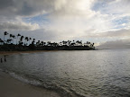
 The south side of Maui is known for its fabulous beaches, and there are plenty of places along Kihei Road to stop and take in some sun and sand. Personal favorite: Kamaole Beach I, at Alanui Ke Alii Road. Or continue a mile or two down the road to the Kihei Boat Launch, where you'll find a nice walking path with benches; a good rest stop before the return trip.
Total Miles: 37 miles
Elevation Gain: close to zero
Route map (bikely.com): Paia-Kihei
Originally we had planned on riding up to Hana from Paia, but after dealing with the elements on our west Maui tour, the prospect of more wet windy riding didn't seem very appealing. Instead we decided to head out to Kihei for a little sunshine. The route is simple: from Paia, take Hana Highway towards Kahului, and follow bumpy Hansen Road to Mokulele Highway. On Hansen Road you'll pass by an aging sugar mill, still in operation. Almost the entire valley between the eastern and western volcanic mountains is planted with sugar cane. According to The Book, one company owns all 37,000 acres of the stuff. That's a lot of sugah.
Where Hansen Road meets the highway, there's a brand-spanking new bikeway running along the eastern side of the highway. The bikeway goes all the way to Kihei, ending at Piilani Highway. Incidentally, the prevailent tradewinds that blow through the valley will push you along effortlessly all the way from Paia to Kihei. Just remember to leave some extra time for the return trip, when you'll be battling the headwinds a bit.
Where the bikeway ends, turn down Uwapo to reach South Kihei Road, which runs alongside the south shoreline for several miles. A marked bikelane comes and goes along this road, but even when it disappears there's generally enough shoulder to feel comfortable.
The south side of Maui is known for its fabulous beaches, and there are plenty of places along Kihei Road to stop and take in some sun and sand. Personal favorite: Kamaole Beach I, at Alanui Ke Alii Road. Or continue a mile or two down the road to the Kihei Boat Launch, where you'll find a nice walking path with benches; a good rest stop before the return trip.Total Miles: 37 miles
Elevation Gain: close to zero
Route map (bikely.com): Paia-Kihei
West Maui Tour (80 miles)
Day 1: Paia/Kahului to Napili
For my first multi-day bicycling tour of the season, I met my cycling buddies in Maui for a two day tour around the western half of the island. We started the ride from the Paia/Kahului side of the island to facilitate the airport exchange, but you could just as easily begin and end from the Kihei/Wailea side. You could also do this route as a long day ride, but you would have to start pretty early in the morning, given the challenging terrain of the last 30 miles.
From Kahului, traveling clockwise, there are two highways that lead to Lahaina and the surrounding communities: the Kuihelani Highway (380) and the Honoapiilani Highway (30). Highway 30 seems to carry less auto traffic and had a bike lane for significant portions, so this seems like the preferred road to take. To get to where the highway begins in Wailuku, you have to snake your way through urban and industrial parts of Kahului which are less than scenic. On the bright side, our meanders took us past a local greasy spoon called Tasty Crust, apparently known island-wide for their pancakes. Perfect fuel for the road!
Leaving Wailuku via highway 30, the tradewinds push you right through the valley at a speedy clip. Past the 7 mile marker, at McGregor Point and Lighthouse, is a pullout that's great for whale-watching. We saw several breaches within just a few minutes. Past mile 10 there's a narrow tunnel that's a bit sketchy, but there's enough shoulder to get by. Another 10 miles down the road is Lahaina, the historic whaling town and tourist trap. (Take Front St. from the highway). Lahaina provides a nice resting point, and there are plenty of options for food and refreshment here. We had a bite to eat at the Pioneer Inn Grill and Bar, which has a great wharf side location but isn't particularly cycling-friendly. The greasy long-haired jackass who was in charge gave us a big stink for parking our bikes on the sidewalk. He was really concerned about us blocking the walkway. Meanwhile, Front Street was a parking lot with a brazillion tourists and their SUVs.
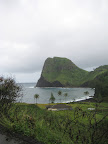
Anyway, from Lahaina we continued on towards our first night's destination, Napili bay, just a few miles past Ka'anapali. Just outside of Napili, the road was actually closed to car traffic while crews worked on some power lines downed by the storm. Luckily we were able to walk our bikes past.
Yeah, the weather was... not so good. It's the rainy season, so you expect some showers, but there was actually a pretty substantial stormfront hanging over the island for most of the week, making for some less than ideal riding conditions. J likened it to riding in Cambodia during the monsoon season. I didn't feel like we got pummeled by too much rain on the West Maui ride, but the roads were wet, muddy, sometimes flooded, with occasional rock slides and other debris on the shoulders. At the end of each day we looked like we had gone mud-wrestling rather than cycling. So, it was certainly nice to arrive in Napili for a brief respite from the rain and mud before we hit the road again for day two.
 Napili has lots of condo rentals that are relatively inexpensive, given the beautiful location (a protected bay with a perfect cresent of sandy beach). Napili Village has spacious studio condos that sleep up to 4 ($160 a night). You can have dinner with a bay view at the Sea House, about a block away. Try the poi, it's tasteless! (at least that's how our waitress marketed it) They also have live music, some good Hawaiian stuff mixed with covers of '70s and '80s classics for the golf course Haoles. Rock on!
Day 2: Napili to Paia
The second day of the ride takes you past the remaining condo towns where few tourists venture. Past Kapalua the road narrows to one lane and traces a sinuous path along the cliffs. Even in good weather this leg of the route would be challenging, with the constant hills, quick descents, and narrow switchbacks. A few brief sections are so steep that I had to use my lowest gear (i.e. walking). In our less than ideal conditions it was a real bear of a ride. But it was still pretty spectacular. It reminded me a bit of stretches of highway 1 in California.. just a bit more lush and tropical.
 There are no services on this stretch of highway, besides a couple small fruit stands in Kahakuloa town. Just past the village begins the only sustained climb of the day: an elevation gain of 1000 feet of so over 2-3 miles. For the most part the road is well graded in this section, so it's actually a pleasant climb compared to some of the steep stuff earlier on. After that, it's all downhill back to Wailuku.
Total Miles: 80
Elevation Gain: unknown
Route maps (bikely.com): Paia-Napili and Napili-Paia
For my first multi-day bicycling tour of the season, I met my cycling buddies in Maui for a two day tour around the western half of the island. We started the ride from the Paia/Kahului side of the island to facilitate the airport exchange, but you could just as easily begin and end from the Kihei/Wailea side. You could also do this route as a long day ride, but you would have to start pretty early in the morning, given the challenging terrain of the last 30 miles.
From Kahului, traveling clockwise, there are two highways that lead to Lahaina and the surrounding communities: the Kuihelani Highway (380) and the Honoapiilani Highway (30). Highway 30 seems to carry less auto traffic and had a bike lane for significant portions, so this seems like the preferred road to take. To get to where the highway begins in Wailuku, you have to snake your way through urban and industrial parts of Kahului which are less than scenic. On the bright side, our meanders took us past a local greasy spoon called Tasty Crust, apparently known island-wide for their pancakes. Perfect fuel for the road!
Leaving Wailuku via highway 30, the tradewinds push you right through the valley at a speedy clip. Past the 7 mile marker, at McGregor Point and Lighthouse, is a pullout that's great for whale-watching. We saw several breaches within just a few minutes. Past mile 10 there's a narrow tunnel that's a bit sketchy, but there's enough shoulder to get by. Another 10 miles down the road is Lahaina, the historic whaling town and tourist trap. (Take Front St. from the highway). Lahaina provides a nice resting point, and there are plenty of options for food and refreshment here. We had a bite to eat at the Pioneer Inn Grill and Bar, which has a great wharf side location but isn't particularly cycling-friendly. The greasy long-haired jackass who was in charge gave us a big stink for parking our bikes on the sidewalk. He was really concerned about us blocking the walkway. Meanwhile, Front Street was a parking lot with a brazillion tourists and their SUVs.
Anyway, from Lahaina we continued on towards our first night's destination, Napili bay, just a few miles past Ka'anapali. Just outside of Napili, the road was actually closed to car traffic while crews worked on some power lines downed by the storm. Luckily we were able to walk our bikes past.
Yeah, the weather was... not so good. It's the rainy season, so you expect some showers, but there was actually a pretty substantial stormfront hanging over the island for most of the week, making for some less than ideal riding conditions. J likened it to riding in Cambodia during the monsoon season. I didn't feel like we got pummeled by too much rain on the West Maui ride, but the roads were wet, muddy, sometimes flooded, with occasional rock slides and other debris on the shoulders. At the end of each day we looked like we had gone mud-wrestling rather than cycling. So, it was certainly nice to arrive in Napili for a brief respite from the rain and mud before we hit the road again for day two.
Napili has lots of condo rentals that are relatively inexpensive, given the beautiful location (a protected bay with a perfect cresent of sandy beach). Napili Village has spacious studio condos that sleep up to 4 ($160 a night). You can have dinner with a bay view at the Sea House, about a block away. Try the poi, it's tasteless! (at least that's how our waitress marketed it) They also have live music, some good Hawaiian stuff mixed with covers of '70s and '80s classics for the golf course Haoles. Rock on!Day 2: Napili to Paia
The second day of the ride takes you past the remaining condo towns where few tourists venture. Past Kapalua the road narrows to one lane and traces a sinuous path along the cliffs. Even in good weather this leg of the route would be challenging, with the constant hills, quick descents, and narrow switchbacks. A few brief sections are so steep that I had to use my lowest gear (i.e. walking). In our less than ideal conditions it was a real bear of a ride. But it was still pretty spectacular. It reminded me a bit of stretches of highway 1 in California.. just a bit more lush and tropical.
There are no services on this stretch of highway, besides a couple small fruit stands in Kahakuloa town. Just past the village begins the only sustained climb of the day: an elevation gain of 1000 feet of so over 2-3 miles. For the most part the road is well graded in this section, so it's actually a pleasant climb compared to some of the steep stuff earlier on. After that, it's all downhill back to Wailuku. Total Miles: 80
Elevation Gain: unknown
Route maps (bikely.com): Paia-Napili and Napili-Paia
Subscribe to:
Posts (Atom)
