Morgan Territory Road is a scenic country road that skirts the eastern side of Mt Diablo, and passes through the Morgan Territory Regional Reserve. The area is named for Jeremiah Morgan, who claimed the entire area as his own in the 1850s. While this road doesn't ascend Diablo itself, it does take you up to about 2000 feet, and the road in some parts is quite steep. So it's definitely not a gimme.
The loop begins and ends at Walnut Creek BART. The Oakland Yellow Jackets have a great turn-by-turn routesheet (pdf) that I more or less followed for this ride.
About 10 miles into the ride you'll pass through the town of Clayton-- first you'll hit the standard suburban sprawl portion of town, then the quaint old downtown area. Clayton is a good place to stop for food and drinks (lots of supermarkets and eateries, and I spotted a Peete's at mile 9.6), or you can make a pitstop at a nice park on Marsh Creek Road called Clayton Community Park. Restrooms and drinking fountains available here.
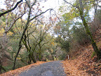 Marsh Creek Road has a lot of auto traffic and not much shoulder, but once I turned onto Morgan Territory Road, the traffic completely disappeared. In 9 miles I passed maybe 5 cars, and surprisingly didn't see any other cyclists. Weird. I had heard that Morgan Territory had lots of steep sections, but the first 6 miles were very gentle. I thought, Hey, this is easy! Then came the last 2-3 miles with lots of nasty steep climbing, but at least there were some stretches of more gentle grade to recover, and lots of shading for sun protection. This stretch of the road was heavily wooded, with oaks and.. other trees (despite that high school biology project that involved collecting all those tree leaves, they still all look the same to me). It almost reminded me of some of the scenery in New Jersey. Maybe my east coast readers will see the pics and disagree.
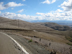
Just before the summit (around 2000 feet) is the Morgan Territory Reserve staging area, with pit toilets and not much else. There was a large orienteering group at the staging area while I was there. That always looks like fun to me; I should look into that and see what the deal is. Past the summit, you begin the descent into the Livermore valley area. It's really striking how quickly the scenery changes at this point. All of that shaded, wooded reserve gives way to arrid grazing hills that are bone-dry this time of year.
 It was like turning a corner and finding yourself on another planet. It's a nice descent though: not technical at all, just a straight, fast shot down to the valley. Once there, the route follows Highland Road and Camino Tassajara (part of the Cinderella Century route-- beware the headwinds!) to return to Danville. Oh, and on Finley Road you have to check out the old Tassajara School, dating to 1889. Quaint!
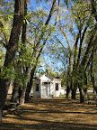
From Danville it's a straight shot up Danville Blvd to the BART station.
Animules: one llama, many horses, some cows, three deer, lots of hawks
Total Distance: 54 miles
Elevation gain: about 3000 feet
Time in the Saddle: 5 hours
Route (on bikely.com): Morgan Territory Loop

2 comments:
Oh man! See, west coast riders can still go biking. East coast riders got hit with 30-40 degrees of winter freshness this weekend and were such weenies they stayed indoors. Waaa. This looks like a gorgeous ride, Carrie. And I'd say that in all my arborial expertise, those falls colors do look familiar. :-) -R
Well I'm still biking, but I was the only cyclist on Morgan Territory on Sunday. So I'm not sure if everyone else has called it a season and I just didn't get the memo?
Post a Comment