I began my Saturday morning by missing the BART train that I had wanted to take from my house to downtown Oakland. Not wanting to wait 20 minutes for the next train, I decided to go ahead and ride down to Lake Merritt. I took my usual commuting route so it felt almost like I was riding into work. On a Saturday. Yay! Anyway, I arrived at the lake, got checked in, and was on the road by 7:30. The weather was overcast and on the cool side, but that was fine with me. I had been hoping for nice cool weather for this ride. The east side of the Oakland hills can really heat up this time of year, and I was hoping to avoid climbing "the bears" in 90 degree heat.
First climb of the morning was up Old Tunnel Road to Skyline. This is my usual route into the Oakland hills, so it was a piece of cake. Up on Skyline (elevation about 1400 ft), the fog was hugging the hills and visibility was very low. Once I started zipping along the Skyline ridge (past first rest stop at Sibley park), I briefly wished I had brought some of my winter gear along. It was cold, people.
From Skyline, the route took us up and over the Oakland hills into Moraga, then a few miles north to Orinda. For the local cyclists: Skyline > Redwood > up Pinehurst > Canyon > Moraga Way. I arrived at the next rest stop, at the intersection of Bear Creek and San Pablo Dam Road, at 10:15am. At this point the folks doing the 50 mile option turned up Wildcat Canyon to climb back into the Oakland/Berkeley Hills. I was doing the extra loop around the reservoirs, so I continued straight down San Pablo Dam Road.
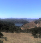 The loop around the San Pablo and Briones Reservoirs is a popular cycling route and is often referred to as "the three bears loop", because there are (at least) three main hills to climb on Bear Creek Road. I usually ride this loop counterclockwise, so this was a little different hitting the climbs in the opposite direction. There were very few cyclists out on the road at this point in the ride. Maybe most riders did the shorter 50 mile option. Losers! At any rate, I was back at the intersection of San Pablo Dam and Bear Creek a little after noon for more snacks and a water refill. At this point I had done about 50 miles and still felt strong.
 The route then crossed San Pablo Dam for a climb up Wildcat Canyon to Inspiration Point. I figured this would be the toughest climb of the day for me, being a bit steeper and coming 50 miles into the ride. Luckily the temperature was still comfortable and the road is relatively shaded, so I made it up that climb without any problems. Then I quickly zipped through Tilden to the other side of the hills, overlooking Berkeley. Then it was up Grizzly Peak for the last climb of the day. At this point fatigue was starting to set in, but fortunately Grizzly Peak is a relatively gentle climb. And I knew that once I got to the top, it was going to be all downhill for the last 12 miles back to Lake Merritt. There was one cyclist on this final climb, let's call her "Anna", who had a bit of hard time and came very close to climbing in the SAG car about 1/4 mile shy of the top of the hill. She held on though and made it to the water stop at the top where her Team in Training cohorts were waiting to cheer her on. Good job Anna!
From the top of Grizzly, route back was Skyline > Shepard Canyon > Snake > Mountain > Park, etc. I pulled into the start/finish point just before 3pm. Pretty good ride!
Total distance: 74 miles
Total time in the saddle: 6.5 hours
Total elevation: 6000 feet
Animules: one deer and one wild turkey along Bear Creek Road

No comments:
Post a Comment