March was a pretty good month, mileage-wise, as I began gearing up for my spring metric and century. Next month I should easily log over 400 miles.
Total mileage: 314
Total time in the saddle: 28.6 hous
Total climbing: 17500 feet
Monday, March 31, 2008
Sunday, March 30, 2008
Diablo via North Gate (35 miles)
I had originally planned on riding up Mt. Tam today, but the weather wasn't cooperating this morning. It was overcast in marin and the city, and for this ride you really want it to be clear so you can enjoy the vistas from the ridge. Alas it will have to wait until another day. In the meantime, I decided to ride up Mt Diablo again, so I could gather more data for my spreadsheet.
The weather in Walnut Creek and Danville was pleasant, and the hillsides are still blooming with wildflowers. While I felt really good all the way up the mountain, my speed didn't improve at all over my last ride two weeks ago. Maybe I felt more comfortable in my pacing but not to the point of pushing to go faster.
It took me 1 hour and 6 minutes to get from the gate to the junction (6.25 miles, 1860 feet of elevation gain), then another 29 minutes to get to Juniper campground, then 31 minutes to reach the summit. So my average speed for each segment was: 5.6 mph (North Gate), 4.8 mph (to Juniper), and 4.1 mph (to the summit). Still slow as hell, but it seems to be getting a bit easier each time.
At the junction, coming back down from the summit, I talked to a guy who was wearing a Death Ride jersey. He said that Monitor pass (the first pass on the Death Ride) was comparable to going up North Gate, but that Ebbetts is more challenging. I asked him if he thought it was a good idea to train at high altitudes, and he said that it doesn't do any good unless you stay at that altitude for the duration. If you go up and train two weeks before the event, but come back down to sea level, then you lose the acclimation. Interesting. I had been contemplating a weekend trip up to Tahoe to get some altitude training in, but maybe it's not worth it.
His other advice for Death Ride preparation was: "climb, climb, climb". Well, duh.
Total Distance: 35 miles
Elevation gain: 4000 feet
Time in the Saddle: 3.5 hours
Friday, March 28, 2008
Three Bears - moderate (47 miles)
One of the most popular rides in the east bay is a loop around the San Pablo Dam and Briones reservoirs via Bear Creek Road. Bear Creek features three hills, which are known as the “three bears”.
The main loop is about 20 miles, but there are several ways to tack on mileage before and after the bears. This ride, a ‘moderate’ route, goes up Old Tunnel Road to Skyline, into Tilden via Grizzly Peak/Wildcat Canyon, and then tackles the bears counter-clockwise.
My cyclo-computer pooped out, so I don’t have good time data for this ride. I did record elapsed time up to Skyline, more or less, since this is my designated time trial section. I completed this section in 48 minutes, I think, which is slightly faster than last time.
Total Distance: 47 miles
Elevation gain: about 4200 feet
Time in the Saddle: unknown; probably about 4.5 hours
Route (on bikely.com): Three Bears
Sunday, March 16, 2008
Mt Diablo - summit via North Gate (34 miles)
So I found out this week that I was selected as part of the Death Ride random lottery (yay me!) so it's going to be a lot of climbing from now until July 12. I also have a metric, a century, and a tour scheduled in between, but I'm not too worried about those. Obviously everything pales in comparison to the death ride in terms of preparation, even when you're only planning on doing 3 passes.
 On all my trips up Diablo I've taken South Gate up to the junction and descended North Gate. South Gate has an average grade of 5% and I had heard that it was noticeably easier than the northern approach. Now that I've got the Death Ride on my schedule, there are no more easy outs. North Gate it is.
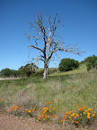
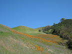
Also, crazy cyclist guy at work said that there was a beautiful patch of poppies along the North Gate approach, and I wanted to check those out.
North Gate definitely has some steeper sections than South Gate, and it doesn't feature the nice flat section on the other side of the mountain (through Rock City). However it does seem more lush than the south side, which has kind of an arid, rocky feel to it. And the southern approach doesn't really have any wildflowers (that I've seen) but the north side has plenty: lots of vibrant orange California poppies, yellow mustard (?), and lots of tiny purple flowers. I'm really bad at identifying specific plants (I'm more of the "pretty flowers!" observer), but I did find this one page on the internets that shows pics of California wildflowers. I'm thinking the purple and yellow ones I saw might be of the lily variety. Next trip up I'll try to take a closer look.
 Speaking of analysis, crazy cyclist guy at work showed me this spreadsheet that he has for the Death Ride. It's populated with the distance and elevation gain for each leg of the ride; you enter your projected feet/min and it calculates how long it will take you to complete each pass. But how do you estimate your feet per minute? I decided (mid-ride today) to develop a similar spreadsheet to record my ride data from each ride up Diablo. The ride up North Gate then up to the summit is relatively similar to the elevation profile of the Death Ride passes (except it's all at much higher elevation of course). By recording my elapsed time on each segment of the ride, I can calculate my average mph as well as my feet/minute. Et voila, I can plug that value into the Death Ride spreadsheet and make sure I won't miss any cutoffs.
I didn't collect data for the first leg, from North Gate gate up to the junction. But from the junction to Juniper campground it took me 28 minutes to cover 2.3 miles and 740 vertical feet (Juniper is at 2940 feet). So my average speed was 4.93 mph and my feet/min was 26.43. Pretty slow, but the next leg was even worse: from Juniper up to the summit my average speed was 4 mph and my feet/min was 25.33. I need to work on doing that climb a bit faster if I'm going to be reasonably comfortable on the Sierra passes.
On all my trips up Diablo I've taken South Gate up to the junction and descended North Gate. South Gate has an average grade of 5% and I had heard that it was noticeably easier than the northern approach. Now that I've got the Death Ride on my schedule, there are no more easy outs. North Gate it is.Also, crazy cyclist guy at work said that there was a beautiful patch of poppies along the North Gate approach, and I wanted to check those out.
North Gate definitely has some steeper sections than South Gate, and it doesn't feature the nice flat section on the other side of the mountain (through Rock City). However it does seem more lush than the south side, which has kind of an arid, rocky feel to it. And the southern approach doesn't really have any wildflowers (that I've seen) but the north side has plenty: lots of vibrant orange California poppies, yellow mustard (?), and lots of tiny purple flowers. I'm really bad at identifying specific plants (I'm more of the "pretty flowers!" observer), but I did find this one page on the internets that shows pics of California wildflowers. I'm thinking the purple and yellow ones I saw might be of the lily variety. Next trip up I'll try to take a closer look.
Speaking of analysis, crazy cyclist guy at work showed me this spreadsheet that he has for the Death Ride. It's populated with the distance and elevation gain for each leg of the ride; you enter your projected feet/min and it calculates how long it will take you to complete each pass. But how do you estimate your feet per minute? I decided (mid-ride today) to develop a similar spreadsheet to record my ride data from each ride up Diablo. The ride up North Gate then up to the summit is relatively similar to the elevation profile of the Death Ride passes (except it's all at much higher elevation of course). By recording my elapsed time on each segment of the ride, I can calculate my average mph as well as my feet/minute. Et voila, I can plug that value into the Death Ride spreadsheet and make sure I won't miss any cutoffs.I didn't collect data for the first leg, from North Gate gate up to the junction. But from the junction to Juniper campground it took me 28 minutes to cover 2.3 miles and 740 vertical feet (Juniper is at 2940 feet). So my average speed was 4.93 mph and my feet/min was 26.43. Pretty slow, but the next leg was even worse: from Juniper up to the summit my average speed was 4 mph and my feet/min was 25.33. I need to work on doing that climb a bit faster if I'm going to be reasonably comfortable on the Sierra passes.
Sunday, March 9, 2008
Marin Headlands-Paradise Loop (about 50 miles)
This ride is basically the classic Tiburon/Paradise ride with a quick Marin Headlands loop thrown in at the beginning for good measure. The full 50 mile route begins and ends at the Embarcadero ferry building in San Francisco, but there are several shorter options that are possible using ferry connections in Tiburon or Sausalito.
For the record, the weather in the bay area could not have been more perfect than it was today. Sunny and warm (even in the city), mild temperatures, hardly any breeze. It was really spectacular, and I congratulate all of the tourists out and about for choosing one hell of a weekend to visit the city by the bay. Trust me, it ain't always like this here, especially in March, so you lucked out.
Anyway, from the ferry building, follow the bike lane north along the embarcadero waterfront, take a left on Beach street, head up or around Fort Mason, and on over to the Marina. Eventually you'll get to the base of the Golden Gate bridge. It's only about 5 miles but you might be tempted to stop for some photo ops, and why not. You'll get some very scenic shots of the bridge from this route along the bay. Public restrooms? Chrissy Field (past the marina but before the bridge) has some good ones. Avoid the restrooms at the bridge visitor area if possible. They stink.
Ride over the bridge (if you're paying attention you'll note that so far this is the standard route to get to Tiburon). In the parking lot on the marin side of the bridge, instead of going to your right to ride into Sausalito, take a left up a steep road. This is Conzelman Road, which wraps around the marin headlands. This initial part is the steepest, but there is more climbing ahead, as well as some scary steep descents. But the views are great, and because the road is narrow and remote, it doesn't seem to attract too much auto traffic.
The marin headlands have some interesting features along with the aforementioned spectacular views. There are two historic forts located here, Fort Barry and Fort Cronkhite, as well as the Point Bonita Lighthouse. Fort Barry was constructed at the end of the 19th century as a line of artillery defense, while Fort Cronkhite was used during World War II as a line of defense against a Pacific invasion. It's hard to imagine anyone invading the bay area via the Golden Gate; it seems more likely that the invaders would come from outer space, but maybe that's why the forts were abandoned.
Exit through the tunnel to meet back up with Sausalito Lateral. Follow this down into Sausalito to continue the Tiburon/Paradise loop.
I've realized that, as many times as I've done the Paradise ride, I've never blogged it. Weird. So, this ride is kind of the default ride to do in Marin, especially if you want something that you can start in the city. It has a bit of everything: the bridge, the artsy tourist trap of Sausalito, multiuse trails through marshlands, one good solid climb, and then 7 or 8 miles along a lovely road that gives the ride its name, Paradise Drive. Paradise drops you down to the Tiburon ferry building; after this point you end up retracing your way back to Sausalito and across the bridge.
The first time I did the ride, several years ago, I did it counter-clockwise. After that I think I've done it exclusively clockwise, which just seems more enjoyable to me, but there's a steady stream of cyclists in both directions, so whatever floats your boat.
Speaking of, because the route passes by two ferry terminals (Sausalito and Tiburon) it's easy to accommodate shorter options of the longer route. Today I had kc meet me in Tiburon after I had done the first 30 miles, and he rode the final 20 miles back to the city, so that's one good option for folks looking to avoid the hilly headlands and the early morning start.
Animules: lots of tourists
Total Distance: 52 miles
Elevation gain: 3500-4000 feet
Time in the Saddle: 4 hours 35 minutes
Route (on bikely.com): Marin-Headlands-Tiburon
State of the rider: Felt good today; passed a guy while climbing Conzelman to the headlands (he was not 80 years old, nor 300 lbs, nor riding a mountain bike); easily passed a chick road cyclist going up the climb to Corte Madera. What, did these people actually take the winter off or something?
Sunday, March 2, 2008
Iron Horse-Dublin Grade (49 miles)
This route is similar to the Oakland Yellowjackets' Dublin Grade route that goes counter clockwise over the Dublin grade and then heads north up to Walnut Creek. This reverse route begins in Orinda and heads south to Dublin as if on the Palomares route, but then turns west at Pleasanton and heads over the Dublin grade to Castro Valley. From there it's a quick jaunt through CV, up past Lake Chabot, and then over to San Leandro BART.
I had wanted to do the Dublin grade this weekend, since I hadn't done it in forever. But the weathermarroons had predicted gusty winds from the north, so by reversing the route and going clockwise, I was able to have a tailwind for 30 miles and only deal with the northerly headwinds briefly near the end of the route. Aren't I smart?
Nothing too remarkable on the ride, but it was nice to see the foothills so green. All the trees are in full spring bloom, as are my allergies. I hate having to blow snot rockets every few miles, because I find it disgusting. But on the other hand, if I'm having to blow my nose every 10 minutes, think of the kleenex I would go through on a 5 hour ride. There's a serious environmental impact to consider.
Animules: some horses
Total Distance: 49 miles
Elevation gain: about 2000 feet
Time in the Saddle: 3 hours 47 minutes
Route (on bikely.com): Iron Horse-Dublin Grade
Subscribe to:
Comments (Atom)
