Sunday, May 18, 2008

Mt Tam Loop (42 miles)

This weekend I doubled up and went riding on both Saturday and Sunday, and finally managed to conquer my remaining mountain summit in the bay area: Mt Tam. But first, on Saturday, I joined Cycling Boss from Work and his buddies for the tail end of their ride, which took us along Skyline to Redwood, and up the southern portion of Pinehurst. From there they continued on to Moraga and Lafayette, while I climbed up the north part of Pinehurst Road to drop back down to Oakland. This was my first time riding with these guys, and I was a little apprehensive since they are all pretty hard core, CBW in particular. This is the guy who rides up Diablo multiple times in a single outing, does double centuries, does the *extra* bonus pass in the Death Ride, etc. Obviously I couldn’t keep up with him, but in general I held my own with the other guys. Anyway, the Saturday ride ended up being 30 miles with 3000 feet of climbing.

For my Sunday ride I decided to finally try for the summit of Mt Tamalpais. My four readers will recall that there are three main peaks in the bay area: Mt Diablo in the east bay, Mt Hamilton in the south bay, and Mt Tam in Marin. One of my cycling goals this year was to get to the summit of all three. I did Hamilton in the fall, and have made it up Diablo several times this winter and spring. Last summer, I inadvertently rode up to the ranger’s station of Tam while doing the Stinson Beach-Muir Woods loop, but that was my last attempt.

Of the three peaks, Mt Hamilton is the highest, at about 4200 feet, but arguably the easiest because it’s a very long, gentle grade for almost the entire climb. Diablo’s summit is at about 3800 feet, and I think conventional wisdom is that it’s the tougher climb compared to Mt Tam, with its highest points at about 2600 feet. However, I personally think Mt Tam is a bit more challenging because there are more steep sections of climbing, and both north and south approaches to the summit road are unevenly graded, so it’s hard for me to find a good climbing rhythm. So from a pure climbing perspective, I still prefer my own mountain here in the east bay, but Tam and the surrounding alpine woods win out in the scenery category.

For this ride I followed the Velogirls routesheet, but instead of riding across the Golden Gate bridge I started in Sausalito to make this a 40+ mile loop rather than a 60+ mile loop. From Sausalito, the route follows the Nicasio route for the first ten miles, up the hill to Corte Madera, then through some really charming towns in Marin (downtown Larkspur, Ross, San Anselmo, and Fairfax). In Fairfax, all the cyclists stop at a local coffee shop called the Fairfax Coffee Roastery. I had a good espresso, but they had some random live music (at 9:30 am??) and the guy kept messing up the lyrics to all the songs. And they weren’t new songs, they were all Elton John and James Taylor songs. Everybody knows the lyrics to those old songs, except this guy playing guitar at the Fairfax Coffee Roastery. Go figure.
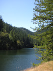
From Fairfax, instead of heading up Sir Francis Drake towards Nicasio, you head south on Bolinas, basically approaching Mt Tam from the north side. I did prefer this approach to the southern route (Panoramic Highway) because there was very little car traffic. In fact, for most of this stretch I heard nothing but birds and crickets in the forest. I think most of the people heading up to the Mt Tam trails or over to the coast take Panoramic Highway rather than the longer, meandering Fairfax-Bolinas route, so you can feel like you’re miles away from civilization on this road. The other nice thing about the road is that it passes by Alpine Lake and the Alpine Dam Bridge, so the scenery is very nice… lots of pine trees surrounding the lake. It’s reminiscent of some of the smaller alpine lakes in the Sierras, near Lake Tahoe, just without the nice clear water. Still, very pretty.

From the Alpine Lake dam up to the ridge at (aptly named) Ridgecrest Road is a gain of about 900 feet in about 2.5 miles, with some pretty steep sections and many switchbacks. I found this part of the ride pretty challenging, but at least it was almost entirely shaded by the surrounding forest. It would be a killer climb if totally exposed.

Once I got up to Ridgecrest, I started hitting lots of trailhead parking lots but absolutely no water fountains. I remembered that I experienced this on my Muir Woods ride too; with all the hiking trails in the Mt Tam area (in the Mt Tam watershed no less!), you’d think they’d have more drinking fountains, but you’d be wrong. As a result, by the time I got to the turnoff to start ascending the summit, I had drained my two water bottles and had no fluids left. One guy helpfully suggested that there were drinking fountains at the visitor center up at the summit (great!) but another cyclist came to my rescue and gave me some of his water. My savior! He noted that it had some sports mix in it, so I would feel like “Lance Armstrong” going up the hill.
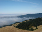
So, up I went. According to this new mapping shareware I downloaded, the first section of the summit climb covers 519 feet in 1.4 miles, for a 7% grade. I didn’t find this section that difficult at all (must have been the “sports mix”!). What’s interesting about Mt Tam is that it really has a couple of peaks: the west peak and the east peak. They’re both about 2600 feet, but there’s a dip in between them, so it’s like a false summit with a kick. But I finally did make it to the east peak, where I drank about 40 oz of water and a root beer. That tasted mighty good. They have a nice little visitor center with picnic tables, snack bar, trails, and various lookout points.

The worst thing about the multiple peak situation is that you have to climb back up on your descent from the summit. It’s cruel and painful, with one section of 6.3% grade and another at 7.8%. But after that, it was literally all downhill to Sausalito.


Total Distance: 42 miles
Animules: a jack rabbit up near the summit
Elevation gain: 4000 feet
Time in the Saddle: 4 hours 23 minutes (wow, that’s pretty slow)

Sunday, May 4, 2008

April mileage stats

Last month I speculated that I would easily log 400 miles in April. In fact I logged 465 miles, 38.3 hours, and over 23,000 feet of climbing. Not bad for mid-spring. May should be a 500+ mile month, when I'll be in full Death Ride training. Should be fun!

Wine Country Century (100 miles)

This Saturday was the Santa Rosa Wine Country Century, a really gorgeous ride that manages to capture most of the flavors of Sonoma wine country.. quaint towns, vineyards, rolling hills, redwood forests, the Russian river valley, etc. This is the second year in a row I’ve tackled the century route (I did the metric a few years back) and it remains one of my favorite rides. This year I definitely felt stronger than last year, when I felt so relieved when I crossed the finish line that I actually had tears in my eyes. It’s a relatively flat ride for a century, about 3500 feet of climbing, but it’s still challenging enough to feel like a real accomplishment. Next year I’d really like to do the double metric route, their 120 mile option that mostly follows the century route but includes a loop out to the coast at Bodega bay.

I traveled up to Santa Rosa on Friday night and stayed at the Fountaingrove Inn, just 2 miles south of the ride start. Parking at the ride start is a bit of a pain, so it’s nice to be able to ride there directly from the hotel. Side note: this was my first stay at the Fountaingrove Inn, and I was quite pleased. It’s a nice low-key upscale hotel, and the room was really well insulated. Even though I was right next to the lobby, I didn’t hear a thing all night and was able to get a great night’s sleep.

Saturday morning I left the hotel just after 6:30 and was at the official route start by 6:45. The first 20 miles of the route are really flat and easy, and really the only part of the ride where I’m able to take advantage of the pseudo-peleton effect. That is, I can tag along with big groups of riders and go at a very comfortable 20 mph pace before the first climb of the day. While riding with one group I chatted with a guy from Alameda who was doing the Wine Country Century 100 mile route and then, the following day, doing the Grizzly Peak century back in Berkeley. That’s what we call hard core.

The first hill of the day was on Graton Road, a nice steady, easy climb. After Graton there’s a quick decent through forested river valley to the first rest stop in Monte Rio, at mile 26. I had wanted to be at Monte Rio by 9:15, but I actually pulled in at 8:37! So I really managed to cover a bit of ground that first leg.

The Wine Country Century has some of the best rest stops, with lots of great food, both hot and cold. Something that they had this year that I thought was brilliant were banana slices with a spoonful of peanut butter and an M&M on top. Simple, but really, really good. Everyone was crowding around this guy constructing the PB&Bs, and he couldn’t make them fast enough.

The next segment of the ride, from Monte Rio to the Wohler Bridge rest stop (mile 48.5), passes through the Russian river community of Guerneville and then snakes through back roads to head back towards Santa Rosa. For the most part this is rolling terrain, although there are two short steep climbs here. The worst is on Green Valley Road, where I managed to get three quarters up by zig-zagging across the road. When that became impossible (too many cyclists, a car or two), I had to stop and walk the bike the rest of the way. I had to do this last year, too, but at least this year I got much farther up before having to go into my lowest gear. Progress! I was talking to a guy at the top of the hill, and he thought the grade was 14-17%, maybe even 20%. So, I’m not surprised I’ve had to hoof it up that hill; it’s definitely outside of my comfort zone.

I arrived at the Wohler Bridge rest stop at 10:50, having left the first rest stop at 8:50. I covered 22.5 miles in 2 hours, definitely slower than the first segment of the ride, but still a decent pace. I left the rest stop at 11:10, and began heading north through classic wine country terrain: lots of rolling hills, past vineyards, along very poorly paved country roads. Last year this section of the ride killed me, mostly because of steady headwinds. This year there was a very light tailwind, so it was smooth sailing all the way into the lunch stop at Warm Springs Dam at Lake Sonoma (mile 70). At the lunch stop the ride organizers build delicious made-to-order sandwiches; I had turkey with avocado on a whole wheat roll. Perfect! I couldn’t believe how great I felt at the lunch stop, and briefly wondered why I hadn’t tried for the double metric route after all.

Naturally once I hit the road again after lunch, I returned to reality and realized that fatigue was starting to set in. Those light tailwinds while heading north became somewhat strong headwinds traveling south for the final 30 miles. In addition, my Terry saddle really started to bother me quite a bit after mile 75 or so. I struggled a little for the final leg, and was quite happy to pass the cowbells at the finish line at 3:50pm. I did feel much stronger than last year, but also glad that I had not done part of the longer 120 mile route.

I do think that if I had not had the saddle pain on the final leg, I would have felt much better those last 30 miles. I’m going to take the brooks saddle from my other bike and try it out on the dolce, to see how it feels on some long rides coming up. Hopefully that will do the trick.


Event begin and end: 6:47am – 3:53pm

Total Distance: 100 miles
Elevation gain: 3500 feet
Time in the Saddle: 7 hours 46 minutes

Tuesday, April 29, 2008

CFGFC Almost-Century (hilly) 82 miles

This being the last training weekend before the Wine Country Century, I decided to double up and do a short hilly ride on Saturday and then a longer hilly ride on Sunday. The Saturday ride was just a short jaunt up to the East Bay Hills ridgeline and down through Berkeley.. about 3000 feet of climbing in 20 miles. Sunday I decided to do a hilly version of the CFGFC loop.

The original CFGFC route was designed to be the flattest century possible in the bay area. Since I've developed better climbing legs, I've been thinking about ways to incorporate more climbing into the route. This modified route begins by climbing over the east bay hills (rather than going around them) and incorporates the challenging Palomares Road climb at around mile 60. From Castro Valley the route heads up past Lake Chabot and drops you into San Leandro, at which point you once again realize that it's impossible to avoid riding through the Oakland ghetto. Sigh.

The weather was very pleasant this weekend, with sunny skies and warm temperatues. However, once mid day hit it really started roasting out there. The climb up Palomares was a bit challenging given the heat, but surprisingly I seemed to be fairing better than some of the other cyclists on the road. Maybe all of this training is starting to pay off.

Past Lake Chabot I decided to forgo the additional climbing along the foothills and stick to the flats. Too bad the flats are through some of the worst parts of Oakland. I sped right through the last 15 miles and hopped on BART at Fruitvale station. I didn't feel great, but I could have done a few more miles if pressed. I'd say I'm ready for the century this Saturday.

Total distance: 82 miles
Total elevation gain: about 4000 feet

Sunday, April 20, 2008

Nicasio Cheese Factory Loop (80 miles)

Last weekend I had such a tough ride that I couldn't even muster the energy to blog about it. I did a 72+ mile ride down to Calaveras Road during what turned out to be a record-setting heat wave in the bay area. Temperatures were near 90 after being in the 60s to 70s for the past few weeks, and I ended the ride feeling nauseous and dehydrated.

Since last weekend the temperatures have dropped significantly below normal, so this weekend I was hoping to get some good mileage without the added weather conditions. As it turns out, I ran smack into a wind advisory this weekend, of all things. Just my luck.

This ride is from the Velogirls routesheet library, with the following modifications: my route started at Embarcadero BART station and ended on the return at the Sausalito ferry terminal. So, tacking on 5 miles at the beginning of the ride, but cutting off 5 miles and 300+ feet of climbing at the end.

The ride follows the standard route across the Golden Gate Bridge, through Sausalito, and over the hill in Corte Madera. From here the route takes you north/northwest through some nice little towns in Marin County, then through pasture land and redwood forests up to Nicasio and the Petaluma outskirts. I had ridden some of these roads during my 5 day wine country tour in 2005, but I had forgotten how surprising it is to find yourself deep in a shaded redwood forest all of a sudden, after riding through miles of flat grassland. At those moments it's hard to believe that you're just 30 miles outside of a major urban center; you might as well be hundreds of miles away from anything.

Just north of Nicasio is the Marin French Cheese Factory, also known as the Rouge et Noir cheese factory. (Whether this is in reference to Stendhal, or some veiled commentary on the army and religion, love and death, or fortune of the roulette wheel is unknown. The young girl manning the cash register seemed unlikely to have a strong opinion on the matter). The cheese factory has been in business since 1865 producing French-style cheese in the bay area, and they claim they are the oldest continually operating cheese factory in the U.S.

The 40 miles up to the cheese factory would have been more pleasant had it not been for the sustained headwinds. I found out later that there had been a wind advisory in effect the whole day, with winds from the north-northwest gusting up to 50 mph. Naturally the entire ride up to Nicasio was in the north/northwest direction.

Returning from the cheese factory, the route takes a nice jog along Point Reyes-Petaluma Road, past the Nicasio Reservoir, and then meets up with the Cross Marin Trail. This is a really nice multiuse paved trail that runs along Lagunitas Creek, parallel to Sir Francis Drake Blvd. The path goes through beautiful redwood forest and grassland, then passes through a state park, before intersecting with Sir Francis Drake.

The ride back to Sausalito was smooth sailing, heading south more or less, so the strong wind was at my back. Even taking the ferry back to the city, it was still a long day in the saddle.

Total distance: 78 miles
Total elevation gain: about 5000 feet

Wednesday, April 9, 2008

Time Trial: Old Tunnel Road

From now until the Death Ride I plan on riding up Old Tunnel twice a week after work. My goal is to be a climbing machine by July.

I felt strong riding up the hill today, and really pushed myself more than I normally do. In fact I actually felt a little light headed by the time I got to the summit (I also forgot to bring any gels with me, which was dumb). But I managed to shave 5 minutes off my last official time of 46 minutes 30 seconds (back on January 1).

Bike: Specialized Dolce
Actual Ride time: 41 minutes 30 seconds
Total Distance: 5.1 miles

Sunday, April 6, 2008

Cinderella metric century (65 miles)

On Saturday I completed the Cinderella metric century for the third time in as many years. This is a great women-only event sponsored by the Valley Spokesmen bicycle club of Dublin (California, not Ireland). They’ve been putting on this annual ride through Pleasanton and the Livermore Valley for more than 30 years and people really get into the spirit of it. Lots of the cyclists dress up in tutus and tiaras or other costumes. One woman who was riding around my pace the whole day was wearing a Wonder Woman outfit. Good times.

The event begins and ends in Pleasanton, and follows a counter-clockwise loop through the Livermore valley wine country and along the southern foothills of the Diablo/Morgan territory area. It’s a relatively easy route, with only two sections where you have to work: a gradual climb up Cross Road and then a 10 mile stretch of gusty headwinds. But after that section, the final 20 miles are more or less downhill.

The weather in the morning was on the cool side with overcast skies, but I felt good right out of the gates, and only stopped briefly at the first rest stop (at mile 17) to top off my water bottles. I had an early lunch at the main rest stop (mile 30, at 10:40am) and only stopped at the final rest stop for about 5 minutes, so I was able to complete the course rather quickly.

Because the route is pretty easy, I wanted to challenge myself by trying to improve my ride time from last year, which was about 5 hours (actual time in the saddle). I pushed myself a bit on the Cross Road climb and on the headwind section, and figured I was going faster than 75% of the riders on the course without going all out. I clocked my total time in motion at 4 hours and 38 minutes, so I was able to improve on last year’s time quite a bit.


Event begin and end: 8:10am – 1:40pm

Total Distance: 65 miles
Elevation gain: about 1700 feet
Time in the Saddle: 4 hours 38 minutes
Route map (on bikely.com): Cinderella route