Sunday, June 24, 2007

Calaveras Loop (50 miles)

Today's ride was a 50 mile loop focusing on Calaveras Road, a very popular single-lane road that connects the Pleasanton/Sunol area with the town of Milpitas. I believe Calaveras was part of the Tour of California route this year.. stage 3 apparently... it's a very lightly travelled road buffered on one side by the Sunol Regional Wilderness and on the other side by a regional park. The first five miles feature a steady, well-graded climb. My favorite! The next five miles or so are sidewinding rollers that hug the ridge of the foothills.

For the route I followed the Velogirls routesheet for the "Calaveras Mini Loop", but started and finished at different BART stations to tack on some miles.

Weather was generally good, not too hot (75-80 I would say), although somehow I managed to have a headwind in every direction of this loop. I don't know how that's even possible. I must have angered some wind diety, but which one?

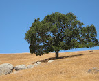
Also, the regional wilderness in this area was all closed to the public, due to extreme fire hazard. I noted last week how dry everything was east of the hills, and certainly everyone is concerned about what the fire season will bring. But when the hills are like this and you come across these isolated trees perched on a wind-blown crest, I'm always captivated by the starkness of the colors.


Animules: a few cows outside of Sunol; some horses
Distance: 51 miles
Time in the Saddle: 4 hours 18 miles

Sunday, June 17, 2007

Surf and Turf (42 miles)

Today's ride ended up being a bit of a mishmash, mostly because of this schizophrenic heat wave we've been experiencing, but also because I overslept. The original plan was to get an early start and ride through Tilden, climb the Bears on Bear Creek Road, then head south through Orinda and Moraga and take Pinehurst back over the hills. With the heavy marin layer that we've had the past few days, I figured I'd have perfect weather to do a lot of climbing.

However.. I woke up (late) to clear sunny skies and climbing mercury. It was already pretty warm by 9 am, so I was a little apprehensive about all the climbing I had planned. I wilt in the heat.

So, first modification: instead of climbing up Spruce and going through Tilden, I decided to BART to Orinda and just go straight to the Bears. I was on the road by 10am, and it was warm, but not heat-stroke warm.

Then once I got through with the Bears, it was about noon and way too warm east of the hills to do much more climbing. So, back to Oakland on BART, where I packed a quick lunch and rode down to the Bay Trail to take advantage of those cool breezes off the bay. The picnic at the Berkeley marina didn't last long though, because it was freezing and blustery down by the water. Figures.

Animules: 3 deer sprinting across Bear Creek Road; lots of horses
Distance: 42 miles
Time in the Saddle: 4 hours

Sunday, June 10, 2007

SF-San Rafael loop

I actually had a specific destination today, rather than just a ride for riding's sake. This weekend was the annual Italian Street Painting Festival in San Rafael, which is one of my favorite street festivals in the bay area, so I decided to take the basic Tiburon/Paradise ride and tweak it a bit to swing through San Rafael. Basically, instead of turning right after the hill on Camino Alto, you continue straight on Magnolia through some lovely expensive residential areas (and some little town called Ross?) until you hit San Rafael. Easy.

This is the first time I've ridden to the festival, so I didn't realize that no bicycles were allowed on the grounds. No problem though, because they had free vallet bicycle parking available. Nice!

As usual I took plenty of pics of the street art. I always like to include the artists in the picture as they work on the drawing, but then I end up with many shots of people's butts as they hover over their work. This is one reason not to be a sidewalk chalk artist.

After the stop in San Rafael, the route proceeds to Larkspur Ferry Terminal, then along Paradise Drive to Tiburon, and then to Sausalito if desired. So there are three possible ferry stops along the route, depending on how long you want to stretch your ride. Here's the map of the route: Gmap-Pedometer route

Animules: none, besides the flocks of birds on the bay
Total distance: 40 miles
Time in the Saddle: 4 hours

Sunday, June 3, 2007

Orinda-Palomares (58 miles)

Today's ride was another BART-to-BART ride, beginning at Orinda BART station and ending at Castro Valley. The first third of the ride takes you through the communities of Moraga, Lafayette, and Danville (a good place for a rest stop).

At Danville, pick up the soutern portion of the Iron Horse Trail and follow it all the way to Dublin. From the Dublin/Pleasanton area you continue south along Foothill until you reach Sunol (another good rest stop before the long climb on Palomares).

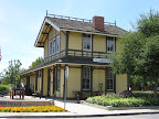
Sunol is a cute little town along Niles Canyon, half way between Pleasanton and Fremont. Main Street features a cafe (established in 1906), a market, a post office, a train depot, and an antique shop. It looks like something out of Little House on the Prairie except for the antique shop, I guess. I bet that originally it was called "General Store" and after a while they decided to change the name rather than the inventory.

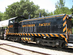
The train depot here is interesting: during the 19th and early 20th century, Sunol and Niles were important railway towns. Both the Union Pacific and Southern Pacific had tracks through Sunol. The Southern Pacific tracks were abandoned in the 1980s, but a company acquired the rights and they now run steam train rides between Niles and Sunol on the weekends.

This afternoon, the train had just arrived and passengers were disembarking, wondering what the hell they were going to do in Sunol before the train took them back to Niles. I was in the market getting water and Gatorade, and one train passenger came in to ask where the nearest bar was (answer: nowhere close).


Continuing on: leave Sunol and proceed west on Niles Canyon Road for about 4 miles, until you get to the turnoff for Palomares Road. This is a very pleasant country road that runs about 10 miles along a creek and through ranches, vineyards, and pastures until you end up on Castro Valley Blvd. The first mile has some really steep sections, but after that the grade evens out and is a pretty nice climb for the next few miles. The summit is at 1000-1200 feet, and the descent is fast and easy into CV.

At some point I'd like to visit the wineries on Palomares Road. I noticed that both Westover and Chouinard had tasting rooms.


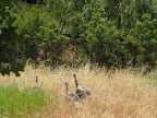
Animules: 3 wild (or very free range) turkeys, lots of horses and cows
Distance: 59 miles
Time in the Saddle: 5 hours

Saturday, June 2, 2007

Rear wheel saga

I've been having ongoing issues with the rear wheel on my Terry Classic for a couple months now. It rode fine for a thousand miles or so, and then I broke a spoke (first one ever). Got it fixed, then a month later, broke another spoke. Then 3 weeks later, another. I don't know if there was something wrong with the wheel to begin with, but from what I've read on the internets, once you have a few broken spokes, it's all downhill from there.

At the end of April I took my Terry into the shop where I bought it, and we decided that we would rebuild the rear wheel with the existing hub, better spokes, and a new rim. It would be a bionic wheel! So we dutefully filled out the order form for the rim and the guy at the shop told me it would take a week or two for the rim to arrive and then a couple of days to rebuild the wheel. No problem!

But then one week went by, and then another. I called the shop, talked to the orders guy, and he said he'd look into it and get back to me. But he didn't. The next week I called and talked to someone different, who said she'd look into it and get back to me. She didn't. Clearly the phone thing wasn't working, so I went back down to the shop and felt like I was starting from square one all over again... even though I was dealing with the original guy I had placed the order with 6 weeks ago. Anyway, he ended up offering me a loaner wheel until my new Velocity rim arrives, and he switched out the cassettes and got me all set up today.

So, the good news is, I have my Terry back and I can stop riding my old beater to work. And it was really cool of this guy to loan me a pretty nice wheel (definitely nicer than my own). But I still have no idea what happened to that order or when the new rim will arrive.

Wednesday, May 30, 2007

May mileage stats

I had to stretch my commute a bit today, but I managed to crack 400 miles for the third month in a row (April was the high month with 431 miles). I expect to drop down a bit in June and July before going back up in August with the big California coast ride.

May miles logged: 400
Total time in the saddle: 33.2 hours

Monday, May 28, 2007

Oakland Hills Ramble 1 (37 miles)

This ride is a good way to explore the Berkeley and Oakland Hills a bit without having to climb any of the really steep grades. I usually do this ride as a home-to-BART ride (starting in Rockridge and ending at a BART station) but you can tack on an extra 15 miles and make it a full loop if you really want.

Start in Rockrige or North Berkeley and head over to Spruce Street (I take Milva to Rose to Spruce, but do it the way you like). Climb Spruce to enter Tilden park, and follow Wildcat Canyon Road/East Park Drive past Inspiration Point and down to Camino Pablo. Take Camino Pablo/Moraga Way through Orinda and Moraga until you get to Canyon Road. This is a good resting point, as there are plenty of places to fuel up and take a bio break. The gas station on the corner has a restroom, but if you want a nicer restroom, turn left on Moraga Road and proceed about a quarter of a mile to the Moraga Commons Park, at the Lafayette-Moraga Regional Trail head where Moraga Road meets St Mary's Road. Nicest public restrooms in the bay area.

After resting, head down Canyon Road until you get to Pinehurst Road. If you turn right on Pinehurst, you'll have a lovely climb through Redwood forest culminating in a hideously steep section before you get dumped onto Skyline. Very scenic, very popular route, but that's for another day. Instead, turn left on Pinehurst.

The first half mile on Pinehurst takes you through Redwood forest, but it quickly opens up to slightly more arrid vegetation. It's still scenic, but it's not as shaded as the other section of Pinehurst, so it can heat up quickly. The climb up Pinehurst is pleasantly graded and lasts for a mile or two. After a brief descent, turn left onto Redwood Road. Redwood Road follows the eastern ridge of the Oakland Hills all the way to Castro Valley. It's another nice gradual climb with hardly any steep sections.

After 15 miles through the hills, it's a bit jarring to end up in Castro Valley, but if it's around lunch time then it's a good excuse to stop at one of the few bright spots in CV: Luccas Italian Deli. From Redwood Road, turn right on Castro Valley Blvd and in about two blocks you'll see Luccas on the left side of the boulevard. Great sandwiches, friendly people, and popular with locals.

Alright, after lunch, continue on Castro Valley Blvd and make a right on Lake Chabot Road. At the lake, vear right to stay on the road for a scenic two mile lake-view stretch. As you leave the lake behind, continue on Estudillo for a couple of blocks and make a left on Bancroft.* Then turn right on Dolores and follow it all the way to the San Leandro BART station.

*note: If you want to tack on extra miles, you can make a right on Bancroft and ride into downtown Oakland. However, this section of town is definitely not scenic and is possibly not quite very safe. I've ridden this route many times and have never exactly felt unsafe, but it's really not the route you'd take your family and friends on. But if you really need those extra miles: take Bancroft until it becomes Bond, go left on 42nd Ave., right on International, left on 40th Ave., and right on E 12th Street. This will take you to Fruitvale BART. Continue further on E 12th street to get to Lake Merritt and downtown Oakland.